Plimpton, Simon, Farmhouse

Why it's listed
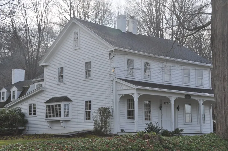
This farmhouse at 561 South Street in Southbridge is a two-and-a-half story, five-bay, center-entry house with a central chimney, gable roof and double-pile plan, a form popular in Central Massachusetts from the late 18th to the mid-19th century. A local leaflet dates it to 1819, though the broad eaves and Greek Revival doorframes suggest mid-century changes, and a porch was added across the facade later in the 19th century. Simon Plimpton is said to have built it with his brother Baxter on land that was part of a tract settled by Col. Daniel Plimpton, who came from Medfield in 1738. Plimpton family members used nearby water power for cotton spinning and wool carding from about 1812, and a shuttle factory opened across the road around 1846. The house, its barn and the surrounding open land were listed for their link to Southbridge's settlement and mill economy and as a well-preserved rural house.
Significance in brief: The nomination ties the house to Southbridge's settlement period and the growth of its mill economy through the Plimpton family. It also values the house as a regionally significant center-chimney form and one of the best preserved examples of 19th-century rural architecture in the town.
Machine-generated summary. This summary was generated by a language model from the official nomination document and has not been reviewed line by line by an editor. It may contain errors. Check the source document before relying on any detail. Source: nomination document (PDF) · National Archives catalog entry. NRHP reference 89000550, listed June 22, 1989. Summary generated October 2026 (model claude-sonnet-5-5, prompt v1.0-2026-10-29, confidence medium).
Key facts
| Address | 561 South St., Southbridge |
|---|---|
| County | Worcester County |
| Listed | June 22, 1989 |
| Reference number | 89000550 |
| Resource type | Building |
| Architect / builder | Architect unknown; said to have been built by Simon Plimpton together with his brother Baxter |
| Architectural style | Federal |
| Criteria |
|
| Areas of significance | Industry, Architecture |
| Level of significance | Local |
| Status (as stated in the nomination) | Condition described as good; present and original use is residential, and the house retains a barn and much of its rural setting. |
| Acreage | 9.2 |
| Coordinates | 42.07521, -72.05486 (NPS GIS) |
What listing means for this property
National Register listing is honorary: it recognises significance and does not restrict what a private owner may do without federal money or permits. It unlocks the 20% federal rehabilitation tax credit for income-producing buildings, state credits in many states, and Section 106 review when federal agencies are involved. See what listing means in practice.
General information, not legal or tax advice. Rules change; confirm with your State Historic Preservation Office or a qualified adviser.
Sources and further reading
- National Park Service, National Register of Historic Places database (snapshot May 2026), reference 89000550.
- Nomination form (PDF, National Archives) — catalog entry
- Wikipedia article (used for cross-checking only; text not reproduced here)
- Wikidata Q7519551
- This listing as JSON
Last updated October 2026. Found an error? See the editorial policy for how to report it.