Partridge, Jabez, Homestead

Why it's listed
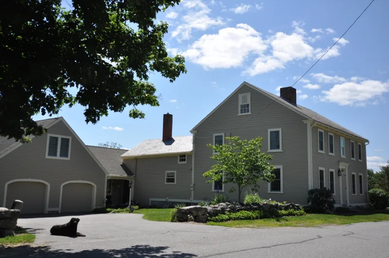
This farmstead on Partridge Road in South Gardner, Massachusetts, centers on a timber-frame house with two parts. The two-storey front section dates from 1826, while the one-and-a-half-storey rear ell is believed to have been built between 1772 and 1786 for Jabez Partridge. The front block has clapboard siding, a central chimney, a granite foundation, a symmetrical facade with a center entry and a boxed, moulded cornice, and some original 12/12 sash. A dairy shed and barn of undetermined age also stand on the property. Jabez Partridge, an early settler, is recorded as establishing a farm here as early as 1772, though no deed was filed until 1786. He signed the 1785 petition to incorporate Gardner, and sold the farm to his son Adam in 1811. Partridge descendants owned it until 1927. The farm has operated continuously since 1786 and retains nearly 28 acres of farmland, preserving the pre-industrial agricultural character of the area.
Significance in brief: The farm has operated continuously since 1786, and possibly since 1772, and is tied to the settlement and agricultural economy of South Gardner. The vernacular Federalist house and nearly 28 acres of farmland remain much as they were in 1826, preserving elements of Gardner's pre-industrial development.
Machine-generated summary. This summary was generated by a language model from the official nomination document and has not been reviewed line by line by an editor. It may contain errors. Check the source document before relying on any detail. Source: nomination document (PDF) · National Archives catalog entry. NRHP reference 79000375, listed December 6, 1979. Summary generated October 2026 (model claude-sonnet-5-5, prompt v1.0-2026-10-29, confidence high).
Key facts
| Address | 81 Partridge Rd., Gardner |
|---|---|
| County | Worcester County |
| Listed | December 6, 1979 |
| Reference number | 79000375 |
| Resource type | Building |
| Period of significance | 1772-1786; 1826 |
| Architectural style | Vernacular Federalist |
| Areas of significance | Exploration/Settlement, Architecture |
| Level of significance | Local |
| Status (as stated in the nomination) | Condition listed as excellent and altered, on its original site; in use as a private residence and agriculture. The rear ell is partly used as a shed. |
| Acreage | 28.8 |
| Coordinates | 42.55847, -71.97046 (NPS GIS) |
What listing means for this property
National Register listing is honorary for a privately owned home: it does not by itself restrict what an owner may do with their own money, and it does not require public access. Restrictions come from local landmark or historic-district ordinances, which are separate (how they differ).
Owner-occupied houses are not eligible for the 20% federal rehabilitation tax credit, which applies to income-producing buildings, but many states offer credits for homeowners. Listing also opens the door to preservation easements and to buying a plaque. Start with what listing means for homeowners, renovating a listed house and selling one.
General information, not legal or tax advice. Rules change; confirm with your State Historic Preservation Office or a qualified adviser.
Sources and further reading
- National Park Service, National Register of Historic Places database (snapshot May 2026), reference 79000375.
- Nomination form (PDF, National Archives) — catalog entry
- Wikipedia article (used for cross-checking only; text not reproduced here)
- Wikidata Q6110149
- This listing as JSON
Last updated October 2026. Found an error? See the editorial policy for how to report it.