Copp's Hill Burial Ground
Also known as: North Burying Place

Why it's listed
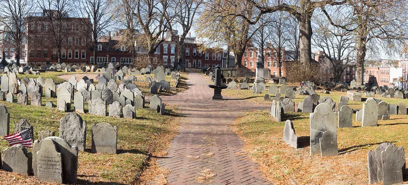
Copp's Hill Burial Ground is a hillside cemetery of about two acres in Boston's North End, bounded by Charter, Snowhill and Hull Streets. It began in 1659-1660 as the colony's second burying ground on land that belonged to shoemaker William Copp, and later additions in 1809, 1819 and 1832 reflected the growth of the city. Its present look comes from the lowering of the summit in 1804-07 and from landscaping in the 1830s. About 227 tombs and nearly 2,000 markers survive in granite, slate and marble. Buried here are Puritan ministers Increase, Cotton and Samuel Mather, shipbuilder Edmund Hartt, Robert Newman and Prince Hall. During the Revolution the British placed a battery on the southwest side, and gravestones were reportedly used for target practice. The markers trace a change from winged death's heads to neoclassical urns and willows. Trees and open ground provide green space in a dense district.
Significance in brief: The form argues the site matters for the notable people buried there, including the Mather family, and for its collection of funerary art showing the shift from Puritan to neoclassical motifs. It also had military significance during the Revolution, when the British placed a battery on the site. Its 1830s landscaping and trees are noted as a small open space in a dense urban area.
Machine-generated summary. This summary was generated by a language model from the official nomination document and has not been reviewed line by line by an editor. It may contain errors. Check the source document before relying on any detail. Source: nomination document (PDF) · National Archives catalog entry. NRHP reference 74000385, listed April 18, 1974. Summary generated October 2026 (model claude-sonnet-5-5, prompt v1.0-2026-10-29, confidence medium).
Key facts
| Address | Charter, Snowhill, and Hull Sts., Boston |
|---|---|
| County | Suffolk County |
| Listed | April 18, 1974 |
| Reference number | 74000385 |
| Resource type | Site |
| Areas of significance | Landscape Architecture, Art, Military, Religion, Social History |
| Level of significance | State |
| Status (as stated in the nomination) | Condition rated good and unaltered; stones show vandalism, erosion and weather damage. The Victorian Gothic toolhouse burned and was replaced by a cement block structure. Interments occurred as recently as 1960. |
| Acreage | 4 |
| Coordinates | 42.36729, -71.05575 (NPS GIS) |
What listing means for this property
Sites (archaeological sites, battlefields, landscapes) are often listed with a restricted address to protect them from looting or disturbance. Listing is honorary for private owners; federal undertakings on or near the site go through Section 106 review, and state laws may protect burials and artefacts regardless of listing.
General information, not legal or tax advice. Rules change; confirm with your State Historic Preservation Office or a qualified adviser.
Sources and further reading
- National Park Service, National Register of Historic Places database (snapshot May 2026), reference 74000385.
- Nomination form (PDF, National Archives) — catalog entry
- Wikipedia article (used for cross-checking only; text not reproduced here)
- Wikidata Q1131544
- This listing as JSON
Last updated October 2026. Found an error? See the editorial policy for how to report it.