Eliot Memorial Bridge

Why it's listed
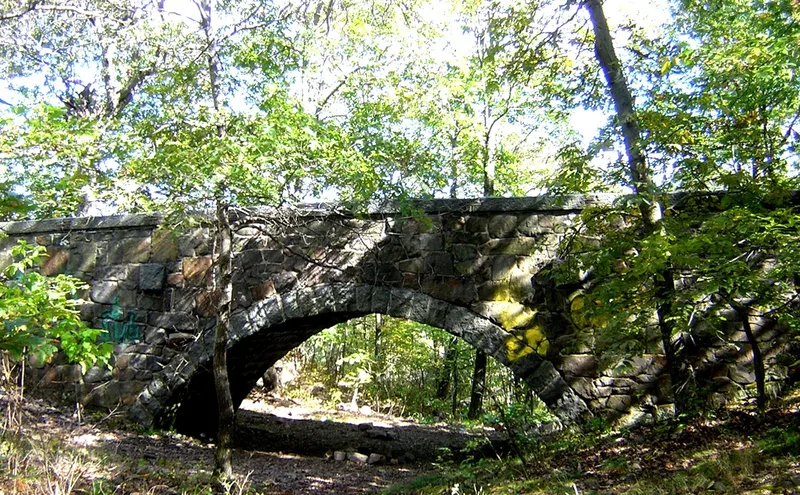
Eliot Memorial Bridge is a native granite bridge on the Skyline Trail near Great Blue Hill in Milton, Massachusetts, completed by 1905 within the Blue Hills Reservation. Built for recreation and as a memorial, it honors Charles Eliot, the reservation's first surveyor and guiding force. Eliot worked with Frederick Law Olmsted's landscape architecture practice and took part in the land survey that preceded the reservation. In 1890 he urged creation of an incorporated association to hold small parcels of land for public enjoyment, and the Trustees of Reservations was founded the following year. The bridge is also valued for its granite block construction. It is one of six historic structures in the reservation built of locally quarried granite, a material exported across the northeastern United States in the nineteenth century. Together these structures show the prominence of the regional granite industry. The bridge remains in good condition and continues to serve recreational and commemorative purposes.
Significance in brief: It is significant for its granite block construction and for its association with Charles Eliot, landscape architect and conservationist who surveyed and guided development of the Blue Hills Reservation. It is one of six historic structures in the reservation built of native Quincy granite. Eliot's 1890 proposal led to the founding of the Trustees of Reservations.
Machine-generated summary. This summary was generated by a language model from the official nomination document and has not been reviewed line by line by an editor. It may contain errors. Check the source document before relying on any detail. Source: nomination document (PDF) · National Archives catalog entry. NRHP reference 80000662, listed September 25, 1980. Summary generated October 2026 (model claude-sonnet-5-5, prompt v1.0-2026-10-29, confidence medium).
Key facts
| Address | Milton, Milton |
|---|---|
| County | Norfolk County |
| Listed | September 25, 1980 |
| Reference number | 80000662 |
| Resource type | Structure |
| Criteria |
|
| Areas of significance | Entertainment/Recreation |
| Level of significance | State |
| Status (as stated in the nomination) | Condition described as good; present use is recreational and commemorative. |
| Acreage | 0.9 |
| Coordinates | 42.21188, -71.11321 (NPS GIS) |
What listing means for this property
For a publicly owned building or structure, listing mainly matters when federal funds, permits or licences are involved: projects then go through Section 106 review so effects on the property are considered. Listing also strengthens applications for preservation grants and, for leased income-producing uses, can enable the federal rehabilitation tax credit.
General information, not legal or tax advice. Rules change; confirm with your State Historic Preservation Office or a qualified adviser.
Sources and further reading
- National Park Service, National Register of Historic Places database (snapshot May 2026), reference 80000662.
- Nomination form (PDF, National Archives) — catalog entry
- Wikipedia article (used for cross-checking only; text not reproduced here)
- Wikidata Q5361247
- This listing as JSON
Last updated October 2026. Found an error? See the editorial policy for how to report it.