Robin Hill Cemetery

Why it's listed
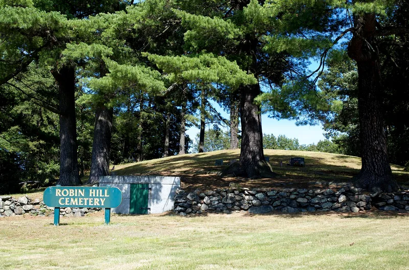
Robin Hill Cemetery is a one-acre burial ground in the northwest corner of Marlborough, Massachusetts, now surrounded by highways and commercial development. Its 24 surviving markers record 27 burials between 1817 and 1999. The western two-thirds occupies a wooded hill about 30 feet high, while the level eastern section is laid out in a grid of 25 small family lots. A fieldstone wall encloses the site, and a granite-faced receiving tomb is set into the wall along the street. Most headstones are simple marble, with a single slate stone carved with a willow and urn. The graves include a Revolutionary War veteran, three Civil War veterans and one World War II veteran. The cemetery was one of several neighborhood burial grounds established in the early 19th century and taken over by the town after 1855. It was listed for its link to Marlborough's farming history and as an early example of family-lot planning in a small New England cemetery.
Significance in brief: The cemetery is tied to the 19th-century farming neighborhood of northwest Marlborough and to the town's system of neighborhood burial grounds that became municipal after 1855. It shows the shift from informal burying ground to planned cemetery with family lots. Its marble headstones and epitaphs illustrate mid-19th-century funerary styles and sentiment.
Machine-generated summary. This summary was generated by a language model from the official nomination document and has not been reviewed line by line by an editor. It may contain errors. Check the source document before relying on any detail. Source: nomination document (PDF) · National Archives catalog entry. NRHP reference 04001083, listed September 29, 2004. Summary generated October 2026 (model claude-sonnet-5-5, prompt v1.0-2026-10-29, confidence high).
Key facts
| Address | Donald Lynch Blvd., Marlborough |
|---|---|
| County | Middlesex County |
| Listed | September 29, 2004 |
| Reference number | 04001083 |
| Resource type | Site |
| Period of significance | 1817 - 1954 |
| Criteria |
|
| Areas of significance | Art, Community Planning and Development, Social History |
| Level of significance | Local |
| Status (as stated in the nomination) | Generally well maintained and retains a high level of integrity, though the surrounding area has changed greatly. It is not generally considered an active cemetery, though residents of the neighborhood may still be buried there. |
| Acreage | 1 |
| Coordinates | 42.36445, -71.59458 (NPS GIS) |
What listing means for this property
Sites (archaeological sites, battlefields, landscapes) are often listed with a restricted address to protect them from looting or disturbance. Listing is honorary for private owners; federal undertakings on or near the site go through Section 106 review, and state laws may protect burials and artefacts regardless of listing.
General information, not legal or tax advice. Rules change; confirm with your State Historic Preservation Office or a qualified adviser.
Sources and further reading
- National Park Service, National Register of Historic Places database (snapshot May 2026), reference 04001083.
- Nomination form (PDF, National Archives) — catalog entry
- Wikipedia article (used for cross-checking only; text not reproduced here)
- Wikidata Q7352468
- This listing as JSON
Last updated October 2026. Found an error? See the editorial policy for how to report it.