Glenwood Cemetery

Why it's listed
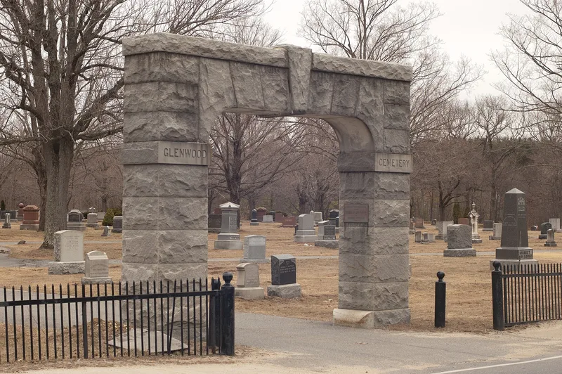
Glenwood Cemetery is a 23-acre municipal burial ground in Maynard, Massachusetts, begun just after the town was established in 1871. It has three parts: the old cemetery, laid out in a geometric pattern of roads and family lots; a new cemetery built by the WPA in the 1930s; and a pond improved in the same decade. Features include a granite entry gate given in 1928, a receiving tomb, and the large granite Maynard family tomb, built in 1880 for mill founder Amory Maynard. The old section holds Victorian marble and granite monuments, some with carved motifs, along with later uniform granite markers. The graves also record the town's mill-working population, with English, Scottish, Finnish, Russian, Polish, Swedish and Greek names, and some sections form distinct ethnic groupings. Mass graves from an 1880s smallpox epidemic and a lot for Civil War veterans add to its record of local history.
Significance in brief: It was one of the first civic improvements of the town of Maynard after its founding in 1871 and is closely tied to the community's history. It is the burial place of founder Amory Maynard and other notable citizens. Its monuments and sections document the ethnic diversity of the mill town's workers, including English, Scottish, Finnish, Russian, Polish and Greek residents. The 1930s WPA work and the Victorian-era monuments add to its landscape value.
Machine-generated summary. This summary was generated by a language model from the official nomination document and has not been reviewed line by line by an editor. It may contain errors. Check the source document before relying on any detail. Source: nomination document (PDF) · National Archives catalog entry. NRHP reference 04000425, listed May 12, 2004. Summary generated October 2026 (model claude-sonnet-5-5, prompt v1.0-2026-10-29, confidence medium).
Key facts
| Address | NE of Parker St. and Great Rd., Maynard |
|---|---|
| County | Middlesex County |
| Listed | May 12, 2004 |
| Reference number | 04000425 |
| Resource type | Site |
| Areas of significance | Art, Community Planning and Development, Social History |
| Level of significance | Local |
| Status (as stated in the nomination) | Described as a well-preserved municipal cemetery still in cemetery use; the receiving tomb is no longer used and the pond is overgrown. |
| Acreage | 23 |
| Coordinates | 42.42561, -71.44502 (NPS GIS) |
What listing means for this property
Sites (archaeological sites, battlefields, landscapes) are often listed with a restricted address to protect them from looting or disturbance. Listing is honorary for private owners; federal undertakings on or near the site go through Section 106 review, and state laws may protect burials and artefacts regardless of listing.
General information, not legal or tax advice. Rules change; confirm with your State Historic Preservation Office or a qualified adviser.
Sources and further reading
- National Park Service, National Register of Historic Places database (snapshot May 2026), reference 04000425.
- Nomination form (PDF, National Archives) — catalog entry
- Wikipedia article (used for cross-checking only; text not reproduced here)
- Wikidata Q5569460
- This listing as JSON
Last updated October 2026. Found an error? See the editorial policy for how to report it.