Northampton Downtown Historic District
Also known as: See Also:Northampton Downtown Historic District (Boundary In

Why it's listed
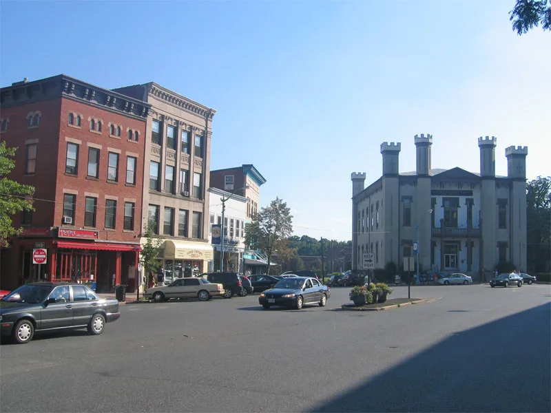
Northampton's downtown historic district occupies roughly 80 acres around the curving line of Main Street, where commercial blocks of red brick sit alongside churches, a courthouse, a city hall, a library and a theater. Most buildings date from the mid- to late nineteenth century and rise two to four stories, so church spires and the courthouse tower still dominate the skyline. Local architect William F. Pratt designed nine of the structures, including City Hall and the Smith Charities Building. The district reflects the town's growth after the railroad arrived, rebuilding after a major fire in 1870, and a second building boom in the 1890s. It also holds the site where Shays' Rebellion began in 1786, the building that was the scene of an 1876 bank robbery, the Academy of Music, an early municipal theater, and the route of the former New Haven-Northampton Canal. Modern signs and storefront changes have affected some facades.
Significance in brief: The nomination argues the district shows how a small early-19th-century New England village became a busy commercial center by the late 19th century. It also holds outstanding examples of a broad range of Victorian architectural styles. The area includes sites tied to Shays' Rebellion, the 1876 Great Bank Robbery, and the New Haven-Northampton Canal.
Machine-generated summary. This summary was generated by a language model from the official nomination document and has not been reviewed line by line by an editor. It may contain errors. Check the source document before relying on any detail. Source: nomination document (PDF) · National Archives catalog entry. NRHP reference 76000270, listed May 17, 1976. Summary generated October 2026 (model claude-sonnet-5-5, prompt v1.0-2026-10-29, confidence medium).
Key facts
| Address | Roughly bounded by Hampton, Pearl, Strong, Bedford, Elm, MA 66, and railroad tracks, Northampton |
|---|---|
| County | Hampshire County |
| Listed | May 17, 1976 |
| Reference number | 76000270 |
| Resource type | District |
| Architect / builder | William F. Pratt (responsible for nine structures in the district); also R. F. Putnam, J. Williams Beal and Sons, Henry F. Kilburn, Peabody and Stearns, James McLaughlin, William Brockelsby |
| Architectural style | Victorian styles including Renaissance Revival, Richardsonian Romanesque, Gothic Revival, Second Empire, Italianate, Queen Anne, Classical Revival and Art Deco |
| Areas of significance | Commerce, Architecture, Performing Arts |
| Level of significance | Local |
| Status (as stated in the nomination) | Occupied and in use as the business, governmental, religious and cultural center of Northampton; condition rated good and altered, with signs, storefront alterations and painted facades noted as disruptions. |
| Acreage | 80.5 |
| Coordinates | 42.31849, -72.63164 (NPS GIS) |
What listing means for this property
This is a historic district. Buildings within its boundary are either contributing (they add to the district's significance) or non-contributing. Owners of contributing income-producing buildings can claim the 20% federal rehabilitation tax credit; homeowners should look at state credits. National Register districts impose no design review by themselves; a local historic district ordinance, if one exists, does (the difference explained).
General information, not legal or tax advice. Rules change; confirm with your State Historic Preservation Office or a qualified adviser.
Sources and further reading
- National Park Service, National Register of Historic Places database (snapshot May 2026), reference 76000270.
- Nomination form (PDF, National Archives) — catalog entry
- Wikipedia article (used for cross-checking only; text not reproduced here)
- Wikidata Q7057611
- This listing as JSON
Last updated October 2026. Found an error? See the editorial policy for how to report it.