Hockanum Rural Historic District

Why it's listed
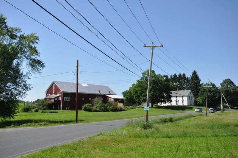
Hockanum is a farming neighborhood in the southwest corner of Hadley, Massachusetts, enclosed by a bend of the Connecticut River and the base of Mt. Holyoke. The district covers about 752 acres of floodplain meadow, terrace pastures, farmsteads, a cemetery and part of Skinner State Park. Its oldest buildings are two farmhouses from the 1740s, including the John Lyman House of 1743 and the White Horse Tavern of 1747, along with later Federal and Greek Revival dwellings and barns. Farms were placed to avoid floods and to catch winter sun. Dairy farming and hay cutting continue today. The district also records the rise of mountain tourism. From the early 19th century, visitors crossed to Hockanum by ferry to climb Mt. Holyoke. In 1851 John W. French built the Summit House and later added a rail line up the mountain. Together, farms and tourist buildings show how agriculture and recreation shaped the landscape from 1740 to 1942.
Significance in brief: The nomination argues the district is a farming neighborhood in continuous agricultural use for centuries. It also contains the features of the famed Mt. Holyoke summit view and the buildings of the 19th-century mountain tourist trade. It is significant for agriculture, architecture, conservation and recreation.
Machine-generated summary. This summary was generated by a language model from the official nomination document and has not been reviewed line by line by an editor. It may contain errors. Check the source document before relying on any detail. Source: nomination document (PDF) · National Archives catalog entry. NRHP reference 93001474, listed December 30, 1993. Summary generated October 2026 (model claude-sonnet-5-5, prompt v1.0-2026-10-29, confidence medium).
Key facts
| Address | Area surrounding Hockanum Rd., from Hockanum Cemetery to the NE corner of Skinner State Park, Hadley |
|---|---|
| County | Hampshire County |
| Listed | December 30, 1993 |
| Reference number | 93001474 |
| Resource type | District |
| Period of significance | 1740-1942 |
| Architect / builder | French, John W. |
| Architectural style | Colonial: Georgian; Early Republic: Federal; Mid 19th Century: Greek Revival |
| Criteria |
|
| Areas of significance | Entertainment/Recreation, Conservation, Architecture, Agriculture |
| Level of significance | Local |
| Status (as stated in the nomination) | Still an active farming area; Summit House has been restored and is now a park visitors' center. Some farm buildings are deteriorated. |
| Acreage | 752 |
| Coordinates | 42.29911, -72.59710 (NPS GIS) |
What listing means for this property
This is a historic district. Buildings within its boundary are either contributing (they add to the district's significance) or non-contributing. Owners of contributing income-producing buildings can claim the 20% federal rehabilitation tax credit; homeowners should look at state credits. National Register districts impose no design review by themselves; a local historic district ordinance, if one exists, does (the difference explained).
General information, not legal or tax advice. Rules change; confirm with your State Historic Preservation Office or a qualified adviser.
Sources and further reading
- National Park Service, National Register of Historic Places database (snapshot May 2026), reference 93001474.
- Nomination form (PDF, National Archives) — catalog entry
- Wikipedia article (used for cross-checking only; text not reproduced here)
- Wikidata Q5875499
- This listing as JSON
Last updated October 2026. Found an error? See the editorial policy for how to report it.