Turner Falls Historic District

Why it's listed
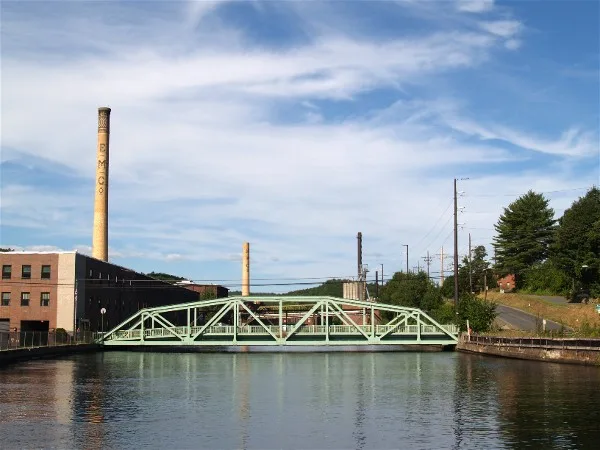
Turners Falls is a planned mill village on a knoll beside the Connecticut River in Montague, Massachusetts. Its roughly 130 acres hold more than 275 properties, mostly built between 1866 and 1886 under Alvah Crocker's concept of an industrial community. A 1867 plan by William P. Crocker and Charles W. Hazelton placed mill sites along a power canal fed by a dam, with the rest of the village on a grid of lettered avenues and numbered streets. Avenue A was laid out as a 100-foot tree-lined avenue. The district includes brick paper mills, a cotton mill, the concrete dam of 1912-15, canal bridges, churches, commercial blocks, and many single and multi-family homes. Industries such as the Keith Paper Company, the Montague Paper Company, the cutlery works and the Turners Falls Company shaped its economy and drew immigrant workers. The district is notable because most of the original buildings survive and few modern intrusions disturb its character.
Significance in brief: The district is a cohesive, largely intact planned industrial community based on Alvah Crocker's concept, with mills powered by a canal and dam system. Its paper, cutlery and cotton mills, the Turners Falls Company's power development, and its late nineteenth century vernacular housing and civic buildings show the growth of a mill village. Immigrant workers settled it to build and run the mills.
Machine-generated summary. This summary was generated by a language model from the official nomination document and has not been reviewed line by line by an editor. It may contain errors. Check the source document before relying on any detail. Source: nomination document (PDF) · National Archives catalog entry. NRHP reference 82004966, listed May 2, 1982. Summary generated October 2026 (model claude-sonnet-5-5, prompt v1.0-2026-10-29, confidence medium).
Key facts
| Address | Roughly bounded by Connectict River, Power Canal, 9th and L St., Turner Falls |
|---|---|
| County | Franklin County |
| Listed | May 2, 1982 |
| Reference number | 82004966 |
| Resource type | District |
| Architect / builder | Plan by William P. Crocker and Charles W. Hazelton (1867); dam by Bates-Rogers Construction Company; bridges by Eastern Bridge and Structural Company; Turners Falls-Gill Bridge by D. O'Connell and Sons |
| Architectural style | Late nineteenth century vernacular |
| Areas of significance | Industry, Community Planning and Development, Commerce, Historic - Non-Aboriginal, Engineering, Architecture, Social History |
| Level of significance | Local |
| Status (as stated in the nomination) | Condition marked good to fair; a large proportion of original buildings survive with few modern intrusions. Some mills, including the Montague Paper Company and the Cutlery buildings, are no longer extant. |
| Acreage | 130 |
| Coordinates | 42.60721, -72.55797 (NPS GIS) |
What listing means for this property
This is a historic district. Buildings within its boundary are either contributing (they add to the district's significance) or non-contributing. Owners of contributing income-producing buildings can claim the 20% federal rehabilitation tax credit; homeowners should look at state credits. National Register districts impose no design review by themselves; a local historic district ordinance, if one exists, does (the difference explained).
General information, not legal or tax advice. Rules change; confirm with your State Historic Preservation Office or a qualified adviser.
Sources and further reading
- National Park Service, National Register of Historic Places database (snapshot May 2026), reference 82004966.
- Nomination form (PDF, National Archives) — catalog entry
- Wikipedia article (used for cross-checking only; text not reproduced here)
- Wikidata Q22059592
- This listing as JSON
Last updated October 2026. Found an error? See the editorial policy for how to report it.