Dighton Rock

Why it's listed
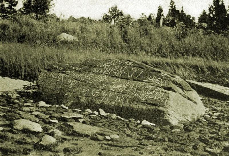
Dighton Rock is a gray feldspathic boulder of about 50 tons beside the Taunton River in a Massachusetts state park. One sloping face carries numerous pecked inscriptions and symbols that appear to combine alphabetic and pictorial forms. Once washed by tidal water, the stone was lifted in 1964 onto a landfill promontory by the state's Department of Natural Resources, though it is now reddening and at risk of crumbling. The carvings were first copied by Rev. John Davenport in 1680, and Cotton Mather described them in 1690. Since then more than 600 books and articles have offered about 35 explanations, from natural weathering to Vikings, Phoenicians and local Indian tribes. The most popular theory, from Professor E. B. Delabarre, reads them as a record of Portuguese explorer Miguel Corte-Real's visit, with his name and the date 1511. Because no explanation can be proven, the rock's lasting interest rests on that enduring mystery.
Significance in brief: The origin of the carved inscriptions is described as one of America's historic mysteries. The figures were first copied in 1680 and have prompted over 600 books and articles and some 35 theories, including Professor Delabarre's claim that they record Miguel Corte-Real's visit in 1511. No definitive evidence supports any single theory.
Machine-generated summary. This summary was generated by a language model from the official nomination document and has not been reviewed line by line by an editor. It may contain errors. Check the source document before relying on any detail. Source: nomination document (PDF) · National Archives catalog entry. NRHP reference 80000438, listed July 1, 1980. Summary generated October 2026 (model claude-sonnet-5-5, prompt v1.0-2026-10-29, confidence medium).
Key facts
| Address | Across the Taunton River from Dighton in Dighton Rock State Park, Dighton |
|---|---|
| County | Bristol County |
| Listed | July 1, 1980 |
| Reference number | 80000438 |
| Resource type | Object |
| Areas of significance | Historic - Non-Aboriginal, Exploration/Settlement |
| Level of significance | State |
| Status (as stated in the nomination) | Rated fair and altered. The boulder was raised in 1964 onto landfill, is reddening through chemical reaction and risks drying out and crumbling. A protective shelter and visitor center was proposed. It is open to the public as a recreational site. |
| Acreage | 0.9 |
| Coordinates | 41.81288, -71.11005 (NPS GIS) |
What listing means for this property
National Register listing is honorary: it recognises significance and does not restrict what a private owner may do without federal money or permits. It unlocks the 20% federal rehabilitation tax credit for income-producing buildings, state credits in many states, and Section 106 review when federal agencies are involved. See what listing means in practice.
General information, not legal or tax advice. Rules change; confirm with your State Historic Preservation Office or a qualified adviser.
Sources and further reading
- National Park Service, National Register of Historic Places database (snapshot May 2026), reference 80000438.
- Nomination form (PDF, National Archives) — catalog entry
- Wikipedia article (used for cross-checking only; text not reproduced here)
- Wikidata Q3098851
- This listing as JSON
Last updated October 2026. Found an error? See the editorial policy for how to report it.