Nye, Elnathan, House
Also known as: Solomon Nye House

Why it's listed
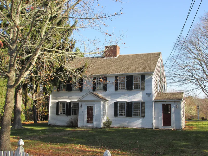
Set on the east side of Old Main Road in North Falmouth, this timber-frame house began as a ca. 1735 half-house and was extended south in 1772 to form a five-by-two-bay Georgian dwelling. It has a gable roof, a brick center chimney, a fieldstone foundation, and clapboard and cedar-shingle walls. Inside are raised-field paneling, plaster on riven lath, wide floorboards, working fireplaces and three beehive ovens. Later changes include a ca. 1850 entrance porch and kitchen wing, a small ca. 1920 wing, and a 1950s restoration of 12/12 window sash. A barn, moved to its present spot ca. 1850, and stone wall remnants complete the 1.55-acre property. Early owners included members of the Nye family, followed by Captain Joshua Crowell, a farmer and coastal mariner who drowned in a storm in 1804, and his widow Bathsheba. Farming ended around 1940, but the surviving house, barn and walls document the evolution of the village and town over more than two centuries.
Significance in brief: The nomination presents the property as an exceptionally complete and well-preserved mid-18th-century dwelling complex that has evolved over time. Its house, barn and walls reflect 260 years of use and illustrate the development of North Falmouth village and the town. The form also traces the Nye and Crowell families, who owned it through farming and maritime eras.
Machine-generated summary. This summary was generated by a language model from the official nomination document and has not been reviewed line by line by an editor. It may contain errors. Check the source document before relying on any detail. Source: nomination document (PDF) · National Archives catalog entry. NRHP reference 02000697, listed June 27, 2002. Summary generated October 2026 (model claude-sonnet-5-5, prompt v1.0-2026-10-29, confidence medium).
Key facts
| Address | 33 Old Main Rd., Falmouth |
|---|---|
| County | Barnstable County |
| Listed | June 27, 2002 |
| Reference number | 02000697 |
| Resource type | Building |
| Architectural style | Colonial: Georgian |
| Areas of significance | Architecture, Community Planning and Development |
| Level of significance | Local |
| Status (as stated in the nomination) | Still used as a single dwelling with a secondary structure; farming ceased ca. 1940 and acreage has gradually been lost. |
| Acreage | 1.6 |
| Coordinates | 41.63577, -70.61932 (NPS GIS) |
What listing means for this property
National Register listing is honorary for a privately owned home: it does not by itself restrict what an owner may do with their own money, and it does not require public access. Restrictions come from local landmark or historic-district ordinances, which are separate (how they differ).
Owner-occupied houses are not eligible for the 20% federal rehabilitation tax credit, which applies to income-producing buildings, but many states offer credits for homeowners. Listing also opens the door to preservation easements and to buying a plaque. Start with what listing means for homeowners, renovating a listed house and selling one.
General information, not legal or tax advice. Rules change; confirm with your State Historic Preservation Office or a qualified adviser.
Sources and further reading
- National Park Service, National Register of Historic Places database (snapshot May 2026), reference 02000697.
- Nomination form (PDF, National Archives) — catalog entry
- Wikipedia article (used for cross-checking only; text not reproduced here)
- Wikidata Q5367016
- This listing as JSON
Last updated October 2026. Found an error? See the editorial policy for how to report it.