Long Point Light Station

Why it's listed
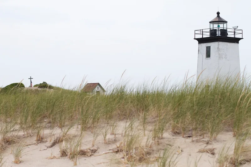
Long Point Light Station occupies a spit of sand at the very end of Cape Cod, at the mouth of Provincetown Harbor, completely exposed to the elements. A light first shone here in 1827, after four acres were bought in 1826. The present square, whitewashed brick tower, 38 feet high, dates from 1875 and has a ten-sided lens room and an iron stair with five landings. A brick oil house, probably of the same year, now holds the generator. The station once included a keeper's dwelling joined to the tower, a barn, a hen house and a pier, making it one of the largest such complexes in Massachusetts. During the Civil War two forts stood beside it. The light was automated in 1952, and solar panels were added in 1982. The station was listed for its integrity and its role in the development of navigation aids in Massachusetts, and for its pairing with Wood End Light.
Significance in brief: The form argues the station keeps integrity of location, design, setting, materials and workmanship. It is important in the development of aids to navigation in Massachusetts. The 1875 tower marks the tip of Cape Cod, where a warning light has stood since 1827, and works together with nearby Wood End Light.
Machine-generated summary. This summary was generated by a language model from the official nomination document and has not been reviewed line by line by an editor. It may contain errors. Check the source document before relying on any detail. Source: nomination document (PDF) · National Archives catalog entry. NRHP reference 87002039, listed September 28, 1987. Summary generated October 2026 (model claude-sonnet-5-5, prompt v1.0-2026-10-29, confidence medium).
Key facts
| Address | Herring Cove Beach, Provincetown |
|---|---|
| County | Barnstable County |
| Listed | September 28, 1987 |
| Reference number | 87002039 |
| Resource type | Structure |
| Criteria |
|
| Areas of significance | Engineering, Transportation, Architecture, Maritime History |
| Level of significance | State |
| Status (as stated in the nomination) | Listed as an unmanned, active aid to navigation owned by the Coast Guard; automated in 1952. Solar arrays were installed on the tower in 1982, and a proposed demolition of the oil house was being reconsidered in 1986. |
| Acreage | 4 |
| Coordinates | 42.03143, -70.16642 (NPS GIS) |
What listing means for this property
For a publicly owned building or structure, listing mainly matters when federal funds, permits or licences are involved: projects then go through Section 106 review so effects on the property are considered. Listing also strengthens applications for preservation grants and, for leased income-producing uses, can enable the federal rehabilitation tax credit.
General information, not legal or tax advice. Rules change; confirm with your State Historic Preservation Office or a qualified adviser.
Sources and further reading
- National Park Service, National Register of Historic Places database (snapshot May 2026), reference 87002039.
- Nomination form (PDF, National Archives) — catalog entry
- Wikipedia article (used for cross-checking only; text not reproduced here)
- Wikidata Q6673081
- This listing as JSON
Last updated October 2026. Found an error? See the editorial policy for how to report it.