Fort Hill Rural Historic District

Why it's listed
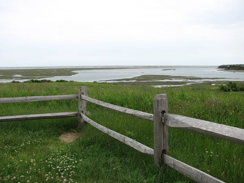
Fort Hill is a roughly 100-acre stretch of fields, woods and salt marsh in Eastham, on the eastern side of Cape Cod, with wide views over Nauset Marsh toward the Atlantic. Two farmsteads, held by the Knowles family and their in-laws the Pennimans, occupied the land without interruption from 1742 to 1943. Three historic houses stand close together along Fort Hill Road: the Second Empire Captain Edward Penniman House of about 1868 with its whalebone gate and barn, the Greek Revival Sylvanus Knowles House of about 1864, and the Georgian Seth Knowles House of about 1790. Stone walls, foundations, property markers and open fields complete the farm landscape, and the walls are rare on Cape Cod. The area also holds a large prehistoric site, and Samuel de Champlain described cleared, inhabited land here in 1605. Creation of the Cape Cod National Seashore in 1961 limited later change while the surrounding region developed.
Significance in brief: The land was farmed by members of a single family, the Knowles family and relatives by marriage, the Pennimans, from 1742 to 1943. The district preserves a rare surviving agricultural landscape, including the Second Empire Penniman House, Georgian and Greek Revival houses, and stone walls unusual on Cape Cod. It also includes land with Native American archaeological significance tied to the early 1600s contact period.
Machine-generated summary. This summary was generated by a language model from the official nomination document and has not been reviewed line by line by an editor. It may contain errors. Check the source document before relying on any detail. Source: nomination document (PDF) · National Archives catalog entry. NRHP reference 00001656, listed April 5, 2001. Summary generated October 2026 (model claude-sonnet-5-5, prompt v1.0-2026-10-29, confidence medium).
Key facts
| Address | Fort Hill Rd, Cape Cod National Seashore, Eastham |
|---|---|
| County | Barnstable County |
| Listed | April 5, 2001 |
| Reference number | 00001656 |
| Resource type | District |
| Architectural style | Late Victorian: Second Empire; Mid 19th Century: Greek Revival; Colonial: Georgian |
| Areas of significance | Agriculture, Architecture, Community Planning and Development |
| Level of significance | Local |
| Status (as stated in the nomination) | The National Park Service owns most of the land and structures, and two historic houses are privately owned. The Penniman House is open seasonally to the public, and fields are still maintained as agricultural land. |
| Acreage | 100 |
| Coordinates | 41.81924, -69.96312 (NPS GIS) |
What listing means for this property
This is a historic district. Buildings within its boundary are either contributing (they add to the district's significance) or non-contributing. Owners of contributing income-producing buildings can claim the 20% federal rehabilitation tax credit; homeowners should look at state credits. National Register districts impose no design review by themselves; a local historic district ordinance, if one exists, does (the difference explained).
General information, not legal or tax advice. Rules change; confirm with your State Historic Preservation Office or a qualified adviser.
Sources and further reading
- National Park Service, National Register of Historic Places database (snapshot May 2026), reference 00001656.
- Nomination form (PDF, National Archives) — catalog entry
- Wikipedia article (used for cross-checking only; text not reproduced here)
- Wikidata Q5471341
- This listing as JSON
Last updated October 2026. Found an error? See the editorial policy for how to report it.