Decatur Cemetery
Also known as: Old Decatur Cemetery; Decatur City Cemetery

Why it's listed
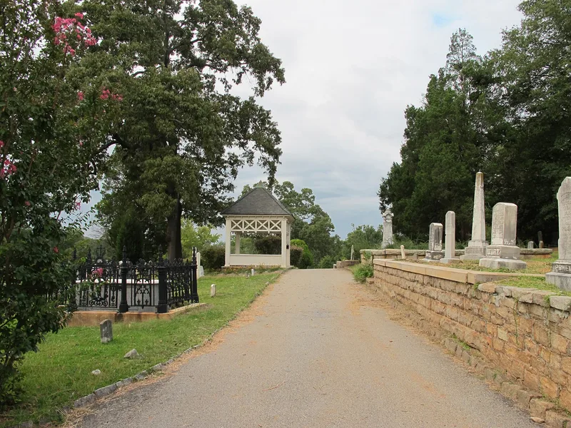
Decatur Cemetery is a 58-acre municipal burial ground on the highest ground northeast of downtown Decatur, Georgia. Burials began by 1826, and the city took responsibility for it in 1832. The oldest section, about 7.5 acres, holds hand-carved pioneer stones, Victorian obelisks, draped urns and ornate iron-fenced lots. A southern portion includes an African-American section with distinctive cast concrete markers, a pauper burial area and graves of orphanage children. In 1881 the city carried out a landscape plan in the spirit of the rural cemetery movement, adding curving roads, granite walks, stairs, terraces, a wrought-iron fence with fieldstone piers and a lattice-detailed wooden well house, now used as a gazebo. Later additions were laid out by civil engineers and landscape architects, including William Pauley. The cemetery was listed for its funerary art, landscape design, community planning role and ethnic heritage. It remains an active cemetery and a public green space used by residents and office workers.
Significance in brief: The nomination argues the cemetery is significant for its well-preserved 19th-century funerary art and sculpture, including iron fencing and early 20th-century Art Moderne and Art Deco stones. It also reflects community planning in a growing county seat and the 1881 rural cemetery movement landscape plan. A distinct African-American section with cast concrete markers adds to its ethnic heritage value.
Machine-generated summary. This summary was generated by a language model from the official nomination document and has not been reviewed line by line by an editor. It may contain errors. Check the source document before relying on any detail. Source: nomination document (PDF) · National Archives catalog entry. NRHP reference 97000459, listed May 23, 1997. Summary generated October 2026 (model claude-sonnet-5-5, prompt v1.0-2026-10-29, confidence medium).
Key facts
| Address | 229 Bell St., Decatur |
|---|---|
| County | DeKalb County |
| Listed | May 23, 1997 |
| Reference number | 97000459 |
| Resource type | District |
| Period of significance | 1826 - 1947 |
| Architect / builder | Landscape architects and civil engineers associated with the site include Robert Scott (1881), W. H. Weaver, C. R. Roberts, William C. Pauley, R. A. Clack, H. D. Rice, Edward L. Daugherty, and Patterson & Dewar. |
| Architectural style | No style (cemetery) |
| Criteria |
|
| Areas of significance | Art, Community Planning and Development, Black, Landscape Architecture |
| Level of significance | Local |
| Status (as stated in the nomination) | Still in use as a public cemetery and green space; the 1881 features have been preserved and maintained. |
| Acreage | 58 |
| Coordinates | 33.78254, -84.29204 (NPS GIS) |
What listing means for this property
This is a historic district. Buildings within its boundary are either contributing (they add to the district's significance) or non-contributing. Owners of contributing income-producing buildings can claim the 20% federal rehabilitation tax credit; homeowners should look at state credits. National Register districts impose no design review by themselves; a local historic district ordinance, if one exists, does (the difference explained).
General information, not legal or tax advice. Rules change; confirm with your State Historic Preservation Office or a qualified adviser.
Sources and further reading
- National Park Service, National Register of Historic Places database (snapshot May 2026), reference 97000459.
- Nomination form (PDF, National Archives) — catalog entry
- Wikipedia article (used for cross-checking only; text not reproduced here)
- Wikidata Q5248766
- This listing as JSON
Last updated October 2026. Found an error? See the editorial policy for how to report it.