Torrey Pines Gliderport

Why it's listed
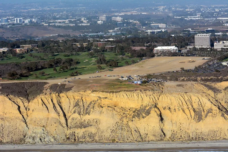
Torrey Pines Gliderport is a 73.6-acre site on a 350-foot cliff above the Pacific in San Diego, where westerly winds create lift for motorless flight. Pilots began launching gliders by car tow from the beach in 1928 and 1929, and in 1936 Woody Brown became the first to launch and land on top of the cliff. John Robinson developed or tested several sailplane advances here in the late 1930s, including the auto-pulley tow launch, a sensitive variometer and improved spoilers. Charles Lindbergh flew along the cliffs in 1930. Annual soaring championships ran at the site from 1947 to 1979, and a 1957 event was televised nationally. The site was listed for its association with aviation and recreation, with a period of significance of 1928-1942. The graded dirt runway and a naval calibration tower contribute to the site. Gliders still fly there today, and it is described as the only remaining gliderport in America directly beside the Pacific Ocean.
Significance in brief: The nomination argues the gliderport is significant for its link to Southern California's aviation industry and as a testing ground for sailplane technology, including the Robinson variometer, pulley-tow launch systems and spoilers. It also notes its role in popularizing soaring through championships and the pilots who learned or flew there, including Charles Lindbergh.
Machine-generated summary. This summary was generated by a language model from the official nomination document and has not been reviewed line by line by an editor. It may contain errors. Check the source document before relying on any detail. Source: nomination document (PDF) · National Archives catalog entry. NRHP reference 93000578, listed July 12, 1993. Summary generated October 2026 (model claude-sonnet-5-5, prompt v1.0-2026-10-29, confidence medium).
Key facts
| Address | W of Torrey Pines Rd., bordering Torrey Pines Scenic Dr. and S and W of Torrey Pines Golf Course, San Diego |
|---|---|
| County | San Diego County |
| Listed | July 12, 1993 |
| Reference number | 93000578 |
| Resource type | Site |
| Period of significance | 1928-1942 |
| Architectural style | No Style |
| Criteria |
|
| Areas of significance | Transportation, Entertainment/Recreation, Invention |
| Level of significance | National |
| Status (as stated in the nomination) | Still used for sailplane operations, with a concessionaire trailer, a small storage building and public parking and beach access on the site. |
| Acreage | 73.6 |
| Coordinates | 32.89074, -117.24613 (NPS GIS) |
What listing means for this property
Sites (archaeological sites, battlefields, landscapes) are often listed with a restricted address to protect them from looting or disturbance. Listing is honorary for private owners; federal undertakings on or near the site go through Section 106 review, and state laws may protect burials and artefacts regardless of listing.
General information, not legal or tax advice. Rules change; confirm with your State Historic Preservation Office or a qualified adviser.
Sources and further reading
- National Park Service, National Register of Historic Places database (snapshot May 2026), reference 93000578.
- Nomination form (PDF, National Archives) — catalog entry
- Wikipedia article (used for cross-checking only; text not reproduced here)
- Wikidata Q7827103
- This listing as JSON
Last updated October 2026. Found an error? See the editorial policy for how to report it.