Pony Express Terminal
Also known as: B.F. Hastings Building
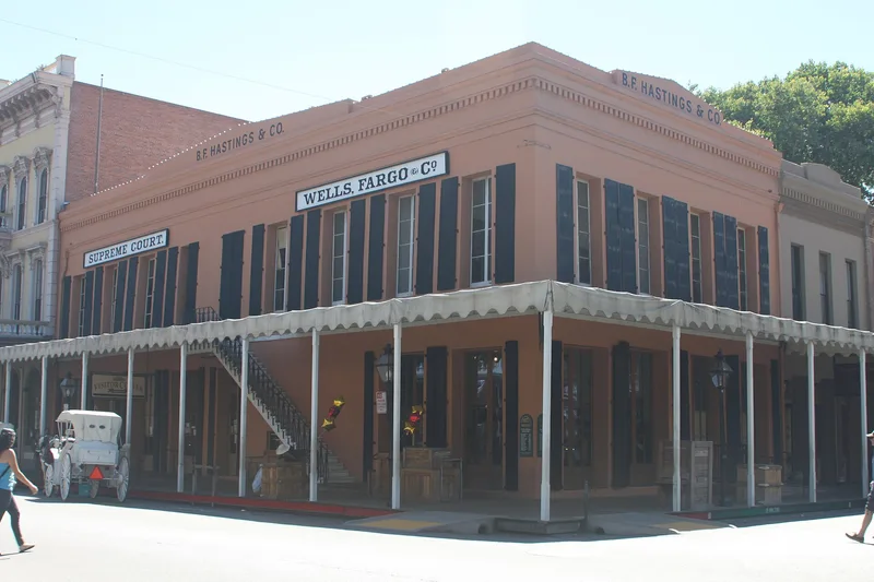

Why it's listed
Sacramento's B. F. Hastings Building, a two-story brick structure at Second and J Streets, served as the western end of the Pony Express from April 1860 to March 1861. The overland mail service was set up by the firm of Russell, Majors, and Waddell to beat the three-month sea route around Cape Horn, and riders sometimes reached the goal of ten-day delivery from St. Joseph, Missouri. The route covered 1,838 miles with 157 stations. The venture lost money and ended when the transcontinental telegraph was completed in October 1861. Only two buildings associated with the service still stand, and this is one of them. The nomination values the building for these events, not for architectural merit. At the time of the form it was being restored: the cement Second Street facade had been removed, new brick was being laid, and the interior was being refinished to recall Sacramento's early American period after 1848. The surrounding area is a nineteenth-century style commercial district.
Significance in brief: From April 1860 to March 1861 the building served as the western terminus of the Pony Express. It is one of only two buildings still standing associated with that episode. The form states its national significance comes from these events rather than from any architectural distinction.
Machine-generated summary. This summary was generated by a language model from the official nomination document and has not been reviewed line by line by an editor. It may contain errors. Check the source document before relying on any detail. Source: nomination document (PDF) · National Archives catalog entry. NRHP reference 66000220, listed October 15, 1966. Summary generated October 2026 (model claude-sonnet-5-5, prompt v1.0-2026-10-29, confidence medium).
Key facts
| Address | 1006 2nd St., Sacramento |
|---|---|
| County | Sacramento County |
| Listed | October 15, 1966 |
| Reference number | 66000220 |
| Resource type | Building |
| Period of significance | 1860-61 |
| Architect / builder | unknown |
| Areas of significance | Communications |
| Level of significance | National |
| National Historic Landmark | Yes, designated July 4, 1961 |
| Status (as stated in the nomination) | Occupied and in good condition, but altered; undergoing extensive restoration with the cement Second Street facade removed, new brick and mortar laid, and the interior being refinished. Owned by the State of California. |
| Acreage | 0.9 |
| Within district | Old Sacramento Historic District |
| Coordinates | 38.58301, -121.50435 (NPS GIS) |
What listing means for this property
National Register listing is honorary: it recognises significance and does not restrict what a private owner may do without federal money or permits. It unlocks the 20% federal rehabilitation tax credit for income-producing buildings, state credits in many states, and Section 106 review when federal agencies are involved. See what listing means in practice.
General information, not legal or tax advice. Rules change; confirm with your State Historic Preservation Office or a qualified adviser.
Sources and further reading
- National Park Service, National Register of Historic Places database (snapshot May 2026), reference 66000220.
- Nomination form (PDF, National Archives) — catalog entry
- Wikipedia article (used for cross-checking only; text not reproduced here)
- Wikidata Q7228455
- This listing as JSON
Last updated October 2026. Found an error? See the editorial policy for how to report it.