Foothill Boulevard Milestone (Mile 11)
Also known as: Bancroft Rd. Marker

Why it's listed
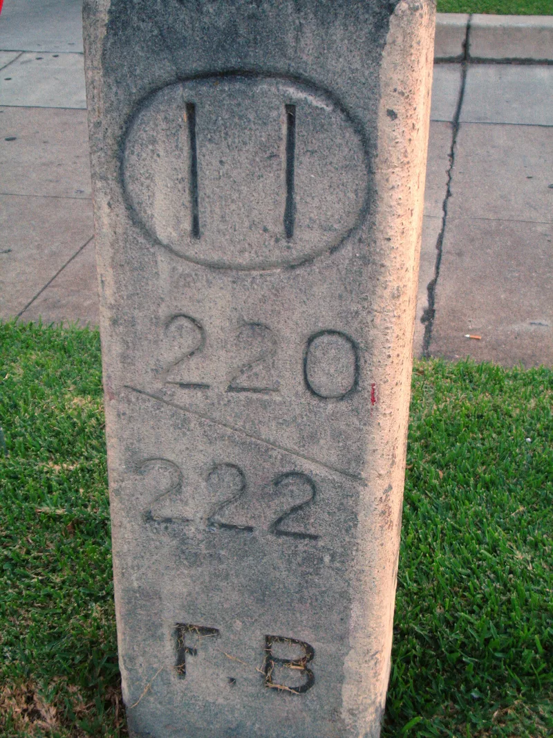
A concrete tablet about five feet long, twelve inches wide and six inches thick sits in the grass strip beside East Colorado Boulevard in Pasadena. Chiseled lettering gives the distance of 11 miles to the old Los Angeles County Courthouse, the block numbers 220/222 and the initials F. B. for Foothill Boulevard. It was installed around 1906 by the Highway Commission of Los Angeles County, which marked six routes with concrete milestones before it was dissolved in 1908. The markers used the Ten Block System developed by Albert L. Bancroft, which divided each mile into ten blocks for addressing and mileage. This milestone is the earliest and only surviving pre-war road marker in Pasadena, and it reflects the Good Roads movement and the growth of automobile travel. A driveway for a new development displaced it in 1994, so it was moved about twenty-five feet east, keeping the same depth, tilt and distance from the curb.
Significance in brief: It is the earliest and only remaining pre-war road marker in Pasadena, one of three known examples there. It represents early efforts by the Good Roads movement and the Highway Commission to build an organized road-marking system in Los Angeles County. Despite a 1994 move of about twenty-five feet, it keeps its setting and historic associations.
Machine-generated summary. This summary was generated by a language model from the official nomination document and has not been reviewed line by line by an editor. It may contain errors. Check the source document before relying on any detail. Source: nomination document (PDF) · National Archives catalog entry. NRHP reference 96000421, listed April 19, 1996. Summary generated October 2026 (model claude-sonnet-5-5, prompt v1.0-2026-10-29, confidence high).
Key facts
| Address | S side of E. Colorado Blvd., W of jct. with Holliston Ave., Pasadena |
|---|---|
| County | Los Angeles County |
| Listed | April 19, 1996 |
| Reference number | 96000421 |
| Resource type | Object |
| Period of significance | c.1906-1908 |
| Architectural style | OTHER: Road Marker |
| Criteria |
|
| Areas of significance | Transportation |
| Level of significance | Local |
| Status (as stated in the nomination) | Relocated about twenty-five feet east in 1994 after a driveway entrance for a new commercial development displaced it; current function listed as vacant/not in use. |
| Acreage | 0.9 |
| Coordinates | 34.14585, -118.12278 (NPS GIS) |
What listing means for this property
National Register listing is honorary: it recognises significance and does not restrict what a private owner may do without federal money or permits. It unlocks the 20% federal rehabilitation tax credit for income-producing buildings, state credits in many states, and Section 106 review when federal agencies are involved. See what listing means in practice.
Noted as vacant in the nomination. Nomination documents can be decades old; current status may differ. If you are considering buying an empty listed property, read the due-diligence checklist.
General information, not legal or tax advice. Rules change; confirm with your State Historic Preservation Office or a qualified adviser.
Sources and further reading
- National Park Service, National Register of Historic Places database (snapshot May 2026), reference 96000421.
- Nomination form (PDF, National Archives) — catalog entry
- Wikipedia article (used for cross-checking only; text not reproduced here)
- Wikidata Q14681977
- This listing as JSON
Last updated October 2026. Found an error? See the editorial policy for how to report it.