Fan Area Historic District (Boundary Increase)
Also known as: See Also:Fan Area Historic District

The pin is a point inside the NPS boundary polygon, not a surveyed location.
Why it's listed
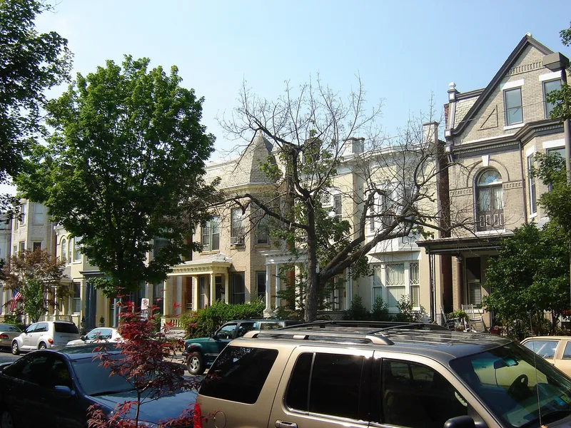
This thirty-seven-block neighborhood in Richmond lies south of West Main Street and continues the Fan Area Historic District. It consists mainly of late 19th- and early 20th-century brick and frame row houses, along with semi-detached and detached town houses, apartment buildings, two churches, corner stores, service stations, a fire station and a former trolley barn complex. Growth followed a trolley line extended along West Main Street in the 1890s, and the street grid reflects an 1817 town plan by Jacquelin Harvie. Local builders and architects often built entire blocks of near-identical rows, and most of the area was developed by 1930. Colonial Revival is the most common style, with Italianate, Queen Anne, Tudor Revival, Craftsman and one Art Deco apartment building also present. The district counts 658 contributing buildings and 42 contributing structures. It was recognized because it shares the character, development history and integrity of the neighboring Fan Area, even though expressway construction and later demolition have affected parts of West Cary Street.
Significance in brief: The extension shares the architectural character, historical development and physical integrity of the contiguous Fan Area Historic District. It contains 658 contributing buildings and 42 contributing structures, with rows of houses built by the same Richmond builders and architects who worked north of Main Street. Its streetscapes show successive styles from Italianate and Queen Anne through Colonial Revival, Tudor Revival, Craftsman and Art Deco.
Machine-generated summary. This summary was generated by a language model from the official nomination document and has not been reviewed line by line by an editor. It may contain errors. Check the source document before relying on any detail. Source: nomination document (PDF) · National Archives catalog entry. NRHP reference 86001190, listed May 30, 1986. Summary generated October 2026 (model claude-sonnet-5-5, prompt v1.0-2026-10-29, confidence medium).
Key facts
| Address | Roughly bounded by W. Main St., S. Harrison St., Richmond Metropolitan Expressway, and S. Boulevard, Richmond (Independent City) |
|---|---|
| County | Richmond (city and county) |
| Listed | May 30, 1986 |
| Reference number | 86001190 |
| Resource type | District |
| Architect / builder | Builders and architects named include Davis Brothers, Inc., E. F. Poindexter, C. W. Morris, S. B. Hazelwood, E. W. Merriman, I. T. Skinner, Peter White, Carl Ruehrmund, Frank Woodall, Charles H. Phillips, B. W. Poindexter, Smith and Woodall, and W. F. Torrence. |
| Architectural style | Late 19th and early 20th century vernacular, Italianate, Queen Anne, Colonial Revival, Tudor Revival, Craftsman, and Art Deco |
| Areas of significance | Community Planning and Development, Transportation, Architecture, Social History |
| Level of significance | State |
| Status (as stated in the nomination) | Mostly residential, with some commercial, religious and transportation uses. The form checks both occupied and unoccupied status, and notes that recent rehabilitation has encouraged revitalization. Some modern intrusions and demolitions have occurred along West Cary Street. |
| Acreage | 100 |
| Within district | James River and Kanawha Canal Historic District |
| Coordinates | 37.54723, -77.46541 (NPS GIS) |
What listing means for this property
This is a historic district. Buildings within its boundary are either contributing (they add to the district's significance) or non-contributing. Owners of contributing income-producing buildings can claim the 20% federal rehabilitation tax credit; homeowners should look at state credits. National Register districts impose no design review by themselves; a local historic district ordinance, if one exists, does (the difference explained).
General information, not legal or tax advice. Rules change; confirm with your State Historic Preservation Office or a qualified adviser.
Sources and further reading
- National Park Service, National Register of Historic Places database (snapshot May 2026), reference 86001190.
- Nomination form (PDF, National Archives) — catalog entry
- Wikipedia article (used for cross-checking only; text not reproduced here)
- Wikidata Q5433597
- This listing as JSON
Last updated October 2026. Found an error? See the editorial policy for how to report it.