Vestal's Gap Road and Lanesville Historic District
Also known as: 53-0007; 53-0498

Why it's listed
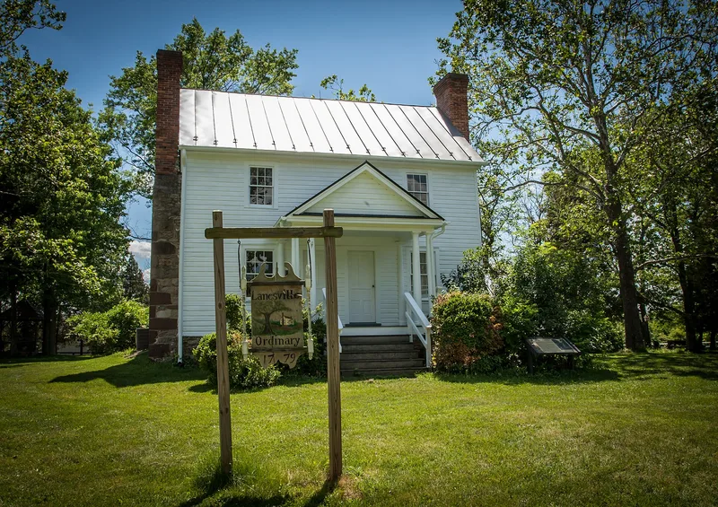
Within Claude Moore Park in Sterling, a short stretch of Vestal's Gap Road runs past Lanesville, a house and tavern built around 1807. The road trace, about six-tenths of a mile long, belonged to an early route from Alexandria and Leesburg toward the Blue Ridge and the Ohio country. Planters hauled tobacco along it, settlers used it to move west, and troops marched on it during the French and Indian War. George Washington also traveled it in 1770. Lanesville is a two-story timber-framed house with a stone foundation and stone end chimneys. It was licensed as an ordinary, serving travelers, and housed the Lanesville post office from 1807. The house was later enlarged and remained in the Bridges family from 1817 to 1941. Newer turnpikes replaced the road by the 1820s. The eastern section keeps the strongest historic character, with an unsurfaced bed and multiple alignments, and the road and house together show early settlement and travel in Loudoun County.
Significance in brief: The road trace is a well-preserved segment of a principal route from Alexandria and Leesburg to the Blue Ridge and the Ohio country, used for commerce, emigration and troop movements including those of George Washington and Braddock's brigade. Lanesville served travelers as an ordinary and housed the Lanesville post office from 1807. Together they illustrate early development of Loudoun County and early republic architecture.
Machine-generated summary. This summary was generated by a language model from the official nomination document and has not been reviewed line by line by an editor. It may contain errors. Check the source document before relying on any detail. Source: nomination document (PDF) · National Archives catalog entry. NRHP reference 99001722, listed February 3, 2000. Summary generated October 2026 (model claude-sonnet-5-5, prompt v1.0-2026-10-29, confidence high).
Key facts
| Address | 21544 Cascades Pkwy., Sterling |
|---|---|
| County | Loudoun County |
| Listed | February 3, 2000 |
| Reference number | 99001722 |
| Resource type | District |
| Period of significance | ca. 1725-Circa 1820 |
| Architect / builder | unknown |
| Architectural style | Early republic |
| Criteria |
|
| Areas of significance | Transportation, Architecture |
| Level of significance | Local |
| Status (as stated in the nomination) | Now part of Claude Moore Park, a county-owned public park used for outdoor recreation; the road is partly graveled and partly grass-covered, and the house has been altered over time. |
| Acreage | 7.5 |
| Coordinates | 39.01926, -77.40684 (NPS GIS) |
What listing means for this property
This is a historic district. Buildings within its boundary are either contributing (they add to the district's significance) or non-contributing. Owners of contributing income-producing buildings can claim the 20% federal rehabilitation tax credit; homeowners should look at state credits. National Register districts impose no design review by themselves; a local historic district ordinance, if one exists, does (the difference explained).
General information, not legal or tax advice. Rules change; confirm with your State Historic Preservation Office or a qualified adviser.
Sources and further reading
- National Park Service, National Register of Historic Places database (snapshot May 2026), reference 99001722.
- Nomination form (PDF, National Archives) — catalog entry
- Wikipedia article (used for cross-checking only; text not reproduced here)
- Wikidata Q14713448
- This listing as JSON
Last updated October 2026. Found an error? See the editorial policy for how to report it.