Malvern Hill (Additional Documentation)

Why it's listed
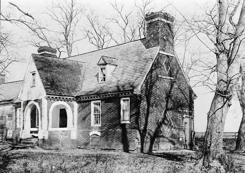
Malvern Hill is the ruin of a brick house set on a high bluff above the James River, east of Richmond in Henrico County. Thomas Cocke, high sheriff of Henrico and a member of the House of Burgesses, built it, and the Cocke family held the property until the late eighteenth century. The chimneys may have come from a wooden house possibly dating to 1662, and the brick house was probably rebuilt around 1690-1700. Photographs show a one-and-a-half story house with a cruciform plan and a steep gable roof. Fire destroyed it around 1905, leaving the foundations and the east gable wall with its massive chimney, which is decorated with diamond-shaped diaper work in glazed brick. The nomination values it as one of the few known cruciform-plan houses in Virginia. The bluff also saw Lafayette's encampment in 1781, Virginia militia in the War of 1812, and the battle between Lee and McClellan on July 1, 1862.
Significance in brief: The nomination argues the house is architecturally important as one of the few known cruciform-plan houses in Virginia, and its surviving chimney is described as perhaps the finest example of seventeenth-century diaper brickwork in the state. The site is also historically tied to military events, including the 1862 battle between Lee and McClellan.
Machine-generated summary. This summary was generated by a language model from the official nomination document and has not been reviewed line by line by an editor. It may contain errors. Check the source document before relying on any detail. Source: nomination document (PDF). NRHP reference 69000248, listed November 12, 1969. Summary generated October 2026 (model claude-sonnet-5-5, prompt v1.0-2026-10-29, confidence medium).
Key facts
| Address | SE of jct. of VA 5 and VA 156, Richmond |
|---|---|
| County | Henrico County |
| Listed | November 12, 1969 |
| Reference number | 69000248 |
| Resource type | Building |
| Architect / builder | Thomas Cocke |
| Architectural style | Cruciform-plan house with diaper brickwork |
| Areas of significance | Military, Architecture, Agriculture |
| Level of significance | National, State, Local |
| Status (as stated in the nomination) | Destroyed by fire circa 1905; only the foundations and east end wall with chimney remain, in ruins, with the brick badly deteriorated and little done to stabilize it. |
| Acreage | 742.71 |
| Coordinates | 37.39806, -77.24082 (NPS GIS) |
What listing means for this property
National Register listing is honorary: it recognises significance and does not restrict what a private owner may do without federal money or permits. It unlocks the 20% federal rehabilitation tax credit for income-producing buildings, state credits in many states, and Section 106 review when federal agencies are involved. See what listing means in practice.
General information, not legal or tax advice. Rules change; confirm with your State Historic Preservation Office or a qualified adviser.
Sources and further reading
- National Park Service, National Register of Historic Places database (snapshot May 2026), reference 69000248.
- Nomination form (PDF, National Archives)
- Wikipedia article (used for cross-checking only; text not reproduced here)
- Wikidata Q6745065
- This listing as JSON
Last updated October 2026. Found an error? See the editorial policy for how to report it.