Franklin Historic District

Why it's listed
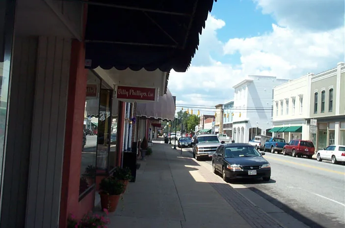
Franklin's historic district covers roughly 70 acres on the western bank of the Blackwater River in southeastern Virginia. It joins a downtown commercial core along Main Street and Second Avenue with a large residential neighborhood centered on High and Clay streets. The village began between 1835 and 1840 beside a railroad bridge and became a depot for regional farm products. After the Civil War, lumber and peanuts drove new growth. Most surviving buildings date from that late 19th-century revival. A fire in 1881 destroyed the original commercial center, and a town ordinance then required brick or stone construction, which explains the rows of Italianate and Colonial Revival brick storefronts. Houses range from vernacular frame dwellings to Queen Anne, Shingle, Bungalow and Foursquare examples, including The Elms. Railroad buildings and peanut warehouses stand near the south end of Main and Mechanic streets. Of 265 structures, 39 are noncontributing.
Significance in brief: The district reflects Franklin's growth as a rail and river commercial center and its later economic resurgence through the lumber and peanut industries. Its cohesive residential streets along High and Clay streets and its brick downtown, rebuilt after an 1881 fire, show the architecture of that prosperity. Only 39 of the 265 structures are noncontributing.
Machine-generated summary. This summary was generated by a language model from the official nomination document and has not been reviewed line by line by an editor. It may contain errors. Check the source document before relying on any detail. Source: nomination document (PDF) · National Archives catalog entry. NRHP reference 85000988, listed May 9, 1985. Summary generated October 2026 (model claude-sonnet-5-5, prompt v1.0-2026-10-29, confidence medium).
Key facts
| Address | US 58 and US 258, Franklin (Independent City) |
|---|---|
| County | Franklin (city and county) |
| Listed | May 9, 1985 |
| Reference number | 85000988 |
| Resource type | District |
| Period of significance | Mid-19th Century to Present |
| Architectural style | Victorian vernacular and Queen Anne residences; Italianate, Colonial Revival, Neo-Classical and Art Deco commercial buildings |
| Areas of significance | Commerce, Transportation, Architecture |
| Level of significance | State |
| Status (as stated in the nomination) | Listed as occupied, in excellent to fair condition, with mixed commercial, residential, educational, religious, government, industrial and transportation uses; many ground floors on Main Street are noted as severely altered. |
| Acreage | 70 |
| Coordinates | 36.67401, -76.92361 (NPS GIS) |
What listing means for this property
This is a historic district. Buildings within its boundary are either contributing (they add to the district's significance) or non-contributing. Owners of contributing income-producing buildings can claim the 20% federal rehabilitation tax credit; homeowners should look at state credits. National Register districts impose no design review by themselves; a local historic district ordinance, if one exists, does (the difference explained).
General information, not legal or tax advice. Rules change; confirm with your State Historic Preservation Office or a qualified adviser.
Sources and further reading
- National Park Service, National Register of Historic Places database (snapshot May 2026), reference 85000988.
- Nomination form (PDF, National Archives) — catalog entry
- Wikipedia article (used for cross-checking only; text not reproduced here)
- Wikidata Q15218400
- This listing as JSON
Last updated October 2026. Found an error? See the editorial policy for how to report it.