Brookneal Historic District
Also known as: VDHR No. 179-5021

Why it's listed
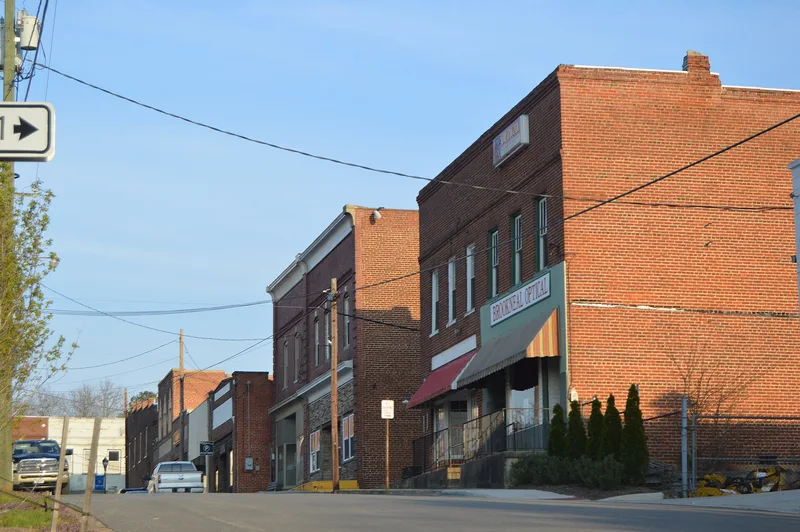
Brookneal's historic district covers about 55 acres in the center of a small Campbell County town on the Staunton River. Its streets follow the ridge routes that once led to ferry and later bridge crossings, and its lots descend from an 1802 town survey. About half of the resources are homes, and the rest are commercial or governmental. Early dwellings, some of log or frame construction with fine stone chimneys, sit at the northern and southern edges. Later I-houses and Folk Victorian homes line Cook Avenue and Wickliffe Avenue. The downtown grew northward to the Lynchburg & Durham rail line, where one-to-three-story brick and block commercial buildings front the street directly, many in Commercial Style with some Colonial Revival and Art Deco examples. The district was listed for its architecture and its role in local commerce between 1812 and 1960. It counts 107 contributing and 14 noncontributing resources, reflecting the rise and later decline of the region's tobacco, furniture and textile economy.
Significance in brief: The nomination presents the district as a symbol of the rise and later decline of Southside Virginia's economy, which was based on agriculture and manufacturing such as tobacco, furniture and textiles. It is significant in Architecture and Commerce, with a period of significance of 1812-1960. It holds a wide range of intact residential and commercial buildings, including Federal, Greek Revival, Victorian, Colonial Revival, Art Deco and Craftsman examples.
Machine-generated summary. This summary was generated by a language model from the official nomination document and has not been reviewed line by line by an editor. It may contain errors. Check the source document before relying on any detail. Source: nomination document (PDF) · National Archives catalog entry. NRHP reference 11000348, listed June 8, 2011. Summary generated October 2026 (model claude-sonnet-5-5, prompt v1.0-2026-10-29, confidence medium).
Key facts
| Address | Adams Ferry Rd., Old Main, Main, E. Rush & Commerce Sts., Lynchburg, Wycliffe & Cook Aves., & Pick St., Brookneal |
|---|---|
| County | Campbell County |
| Listed | June 8, 2011 |
| Reference number | 11000348 |
| Resource type | District |
| Period of significance | 1812-1960 |
| Architect / builder | Johnson, Stanhope; Craighill, Samuel Preston; McLaughlin, James T.; Pettit, Charles |
| Architectural style | Early Republic; Greek Revival; Colonial Revival; Commercial Style; Bungalow/Craftsman |
| Criteria |
|
| Areas of significance | Architecture, Commerce |
| Level of significance | Local |
| Status (as stated in the nomination) | Most buildings remain in use as homes, shops, offices and civic buildings. The Brookneal Milling Company building was destroyed by fire in November 2009. |
| Acreage | 55 |
| Coordinates | 37.04666, -78.93729 (NPS GIS) |
What listing means for this property
This is a historic district. Buildings within its boundary are either contributing (they add to the district's significance) or non-contributing. Owners of contributing income-producing buildings can claim the 20% federal rehabilitation tax credit; homeowners should look at state credits. National Register districts impose no design review by themselves; a local historic district ordinance, if one exists, does (the difference explained).
General information, not legal or tax advice. Rules change; confirm with your State Historic Preservation Office or a qualified adviser.
Sources and further reading
- National Park Service, National Register of Historic Places database (snapshot May 2026), reference 11000348.
- Nomination form (PDF, National Archives) — catalog entry
- Wikipedia article (used for cross-checking only; text not reproduced here)
- Wikidata Q14712090
- This listing as JSON
Last updated October 2026. Found an error? See the editorial policy for how to report it.