Shepherd's Plain

Why it's listed
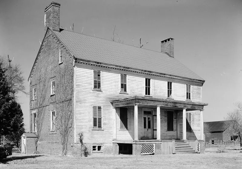
Shepherd's Plain is a Georgian house overlooking Nandua Creek and Kusian Cove near Pungoteague in Accomack County, Virginia. Built between 1755 and 1775 for planter and politician Edward Ker, it has a wood-frame center of five bays flanked by Flemish-bond brick ends. Ker enlarged the familiar one-and-a-half-story, brick-ended Eastern Shore house into a two-story, double-pile dwelling. The north end carries unusual rusticated window trim, raised quoins that follow the roof rake, and rubbed-brick arches, probably inspired by Batty Langley's 1750 builders' guide. Inside, a central hall holds an open-well stair, and the northwest parlor has full paneling, fluted pilasters, and a dentil cornice. The land was patented in the mid-17th century by William Andrews and passed to the Shepherd family before Ker. Despite many owners and a period of abandonment, the house kept its main features, and open fields and water views still surround it.
Significance in brief: The house is significant for its rare rusticated brick trim on the north end and its fine interior woodwork, especially the northwest parlor paneling. These details show the tastes of the Eastern Shore's wealthy class and the skill of local craftsmen working from 18th-century English builders' guides. It was built for Edward Ker, a prominent planter and politician.
Machine-generated summary. This summary was generated by a language model from the official nomination document and has not been reviewed line by line by an editor. It may contain errors. Check the source document before relying on any detail. Source: nomination document (PDF) · National Archives catalog entry. NRHP reference 82004531, listed June 28, 1982. Summary generated October 2026 (model claude-sonnet-5-5, prompt v1.0-2026-10-29, confidence high).
Key facts
| Address | W of Pungoteague, Pungoteague |
|---|---|
| County | Accomack County |
| Listed | June 28, 1982 |
| Reference number | 82004531 |
| Resource type | Building |
| Period of significance | 1700-1799 (specific dates: third quarter 18th century) |
| Architectural style | Georgian |
| Areas of significance | Politics/Government, Architecture |
| Level of significance | State |
| Status (as stated in the nomination) | Described as unoccupied and in good condition, with a period of abandonment in its history; the current owners were restoring it at the time of the nomination. |
| Acreage | 46 |
| Coordinates | 37.62830, -75.84000 (NPS GIS) |
What listing means for this property
National Register listing is honorary: it recognises significance and does not restrict what a private owner may do without federal money or permits. It unlocks the 20% federal rehabilitation tax credit for income-producing buildings, state credits in many states, and Section 106 review when federal agencies are involved. See what listing means in practice.
Noted as vacant in the nomination. Nomination documents can be decades old; current status may differ. If you are considering buying an empty listed property, read the due-diligence checklist.
General information, not legal or tax advice. Rules change; confirm with your State Historic Preservation Office or a qualified adviser.
Sources and further reading
- National Park Service, National Register of Historic Places database (snapshot May 2026), reference 82004531.
- Nomination form (PDF, National Archives) — catalog entry
- Wikipedia article (used for cross-checking only; text not reproduced here)
- Wikidata Q14692393
- This listing as JSON
Last updated October 2026. Found an error? See the editorial policy for how to report it.