Espada Aqueduct
Also known as: Espada Aqueduct and Acequia

Why it's listed
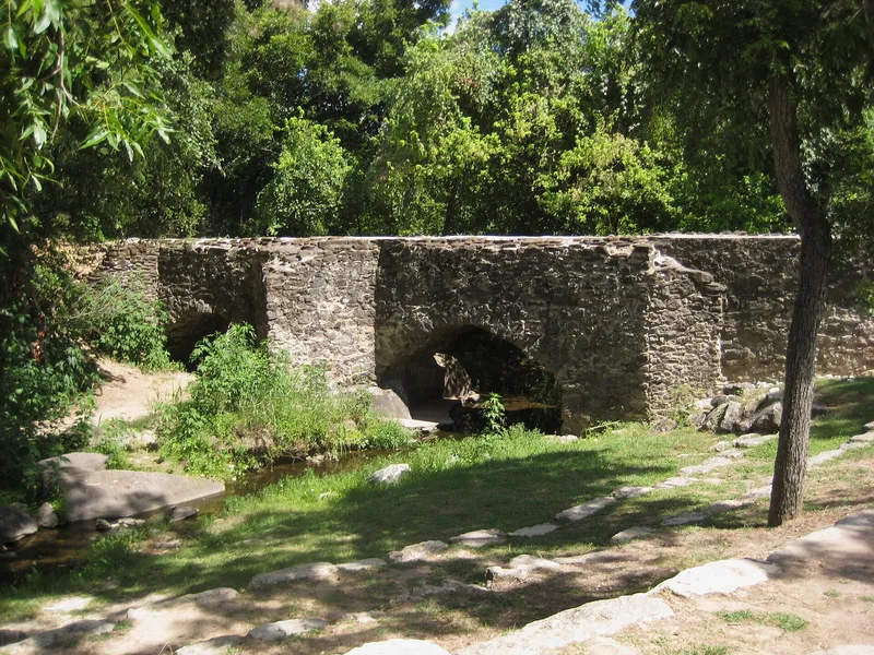
Espada Aqueduct and Acequia form part of an irrigation system built between 1731 and 1745 to supply Mission San Francisco de la Espada, south of downtown San Antonio. A flagstone diversion dam on the San Antonio River feeds a canal that runs about four miles. A masonry aqueduct with two cut-stone arches, 195 feet long and 15.5 feet high, carries the water across Piedras Creek. Lime salts in the water have cemented the stonework, and the aqueduct has survived severe floods even after erosion detached part of its lower section. The canal fell idle in the 1880s, and a private company revived it in 1895. Farmers used it to grow cotton and vegetables, and it still operates. The aqueduct is described as the only Spanish structure of its type left in the United States. The site is recognized as an example of Spanish engineering and of the missions' role in agriculture. Flooding from a nearby flood control project now threatens the aqueduct.
Significance in brief: The acequias of San Antonio were the most extensive Spanish water-supply effort in Texas, and the Espada Acequia is one of the best preserved examples. The aqueduct is described as the only Spanish structure of its type remaining in the United States. Together with the dam and canal, it shows the role of the missions in the agricultural history of the Southwest.
Machine-generated summary. This summary was generated by a language model from the official nomination document and has not been reviewed line by line by an editor. It may contain errors. Check the source document before relying on any detail. Source: nomination document (PDF) · National Archives catalog entry. NRHP reference 66000809, listed October 15, 1966. Summary generated October 2026 (model claude-sonnet-5-5, prompt v1.0-2026-10-29, confidence high).
Key facts
| Address | Espada Rd., E of U.S. 281S, San Antonio |
|---|---|
| County | Bexar County |
| Listed | October 15, 1966 |
| Reference number | 66000809 |
| Resource type | Structure |
| Period of significance | 1731-1745 |
| Areas of significance | Agriculture, Engineering, Exploration/Settlement |
| Level of significance | National |
| National Historic Landmark | Yes, designated July 19, 1964 |
| Status (as stated in the nomination) | Still in use: the acequia, dam and aqueduct continue to operate. The aqueduct is described as severely threatened by increased flooding after a flood control project. |
| Acreage | 1000 |
| Within district | Mission Parkway |
| Coordinates | 29.32461, -98.45519 (NPS GIS) |
What listing means for this property
National Register listing is honorary: it recognises significance and does not restrict what a private owner may do without federal money or permits. It unlocks the 20% federal rehabilitation tax credit for income-producing buildings, state credits in many states, and Section 106 review when federal agencies are involved. See what listing means in practice.
General information, not legal or tax advice. Rules change; confirm with your State Historic Preservation Office or a qualified adviser.
Sources and further reading
- National Park Service, National Register of Historic Places database (snapshot May 2026), reference 66000809.
- Nomination form (PDF, National Archives) — catalog entry
- Wikipedia article (used for cross-checking only; text not reproduced here)
- Wikidata Q5398692
- This listing as JSON
Last updated October 2026. Found an error? See the editorial policy for how to report it.