Belton Standpipe
Also known as: #38

Why it's listed
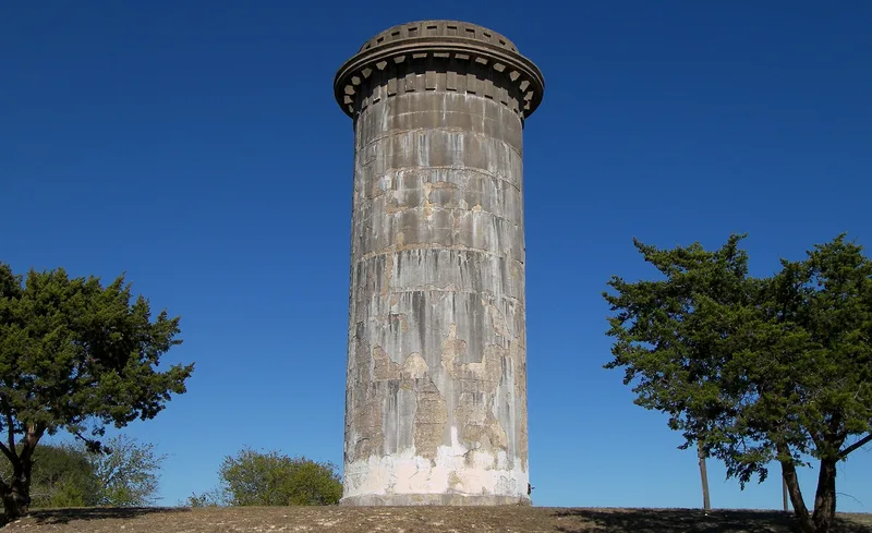
Rising about 70 feet above a small rise in South Belton, this cylindrical standpipe was built in 1914 to serve as the city's water tower. Made of poured, reinforced concrete, it measures roughly 30 feet across. A cantilevered ring near the top carries a service walkway, and raised concrete rectangles below it suggest crenelation or dentils. The surrounding ground is bare of vegetation, so the structure can be seen from many parts of town. It was built when Belton was growing rapidly and city leaders were modernizing utilities, and it became a point of local pride. Concrete standpipes like this were once fairly common but were mostly replaced by steel towers, which makes this one a rare survivor. It also represents reinforced concrete construction, a technology just coming into wide use in the early 1900s. The standpipe is no longer in use and shows cracking and surface spalling.
Significance in brief: The nomination argues it is significant under Criterion A for its link to the initial provision of public services in Belton, and under Criterion C in engineering as a rare surviving early reinforced concrete public works structure. It was once a crucial part of the town's water system and a source of civic pride. Most concrete standpipes of its type were later replaced by steel water towers.
Machine-generated summary. This summary was generated by a language model from the official nomination document and has not been reviewed line by line by an editor. It may contain errors. Check the source document before relying on any detail. Source: nomination document (PDF) · National Archives catalog entry. NRHP reference 90001900, listed December 26, 1990. Summary generated October 2026 (model claude-sonnet-5-5, prompt v1.0-2026-10-29, confidence high).
Key facts
| Address | NW of jct. of TX 317 & I-35, Belton |
|---|---|
| County | Bell County |
| Listed | December 26, 1990 |
| Reference number | 90001900 |
| Resource type | Structure |
| Period of significance | 1914 - 1940 |
| Architectural style | Classical Revival |
| Criteria |
|
| Areas of significance | Community Planning and Development, Engineering |
| Level of significance | Local |
| Status (as stated in the nomination) | No longer in use; described as in poor condition with cracks and surface spalling of the concrete. |
| Acreage | 0.9 |
| Coordinates | 31.04923, -97.46965 (NPS GIS) |
What listing means for this property
National Register listing is honorary: it recognises significance and does not restrict what a private owner may do without federal money or permits. It unlocks the 20% federal rehabilitation tax credit for income-producing buildings, state credits in many states, and Section 106 review when federal agencies are involved. See what listing means in practice.
Noted as vacant in the nomination. Nomination documents can be decades old; current status may differ. If you are considering buying an empty listed property, read the due-diligence checklist.
General information, not legal or tax advice. Rules change; confirm with your State Historic Preservation Office or a qualified adviser.
Sources and further reading
- National Park Service, National Register of Historic Places database (snapshot May 2026), reference 90001900.
- Nomination form (PDF, National Archives) — catalog entry
- Wikidata Q110001562
- This listing as JSON
Last updated October 2026. Found an error? See the editorial policy for how to report it.