Hanging Rock
Also known as: Overhanging Rock

Why it's listed
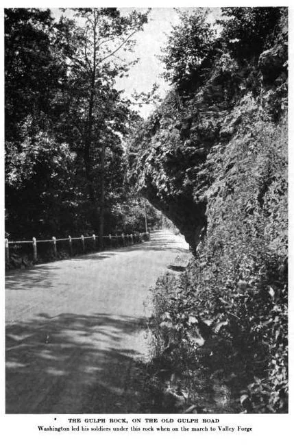
Beside South Gulph Road in Gulph Mills, Upper Merion Township, a natural outcropping of metamorphic phyllite rises above a narrow valley cut by Gulph Creek. The rock overhangs the roadway by about eight feet, and the road itself was formally established as a public road in 1711 and 1712. A small parcel of roughly 24,000 square feet containing the rock was deeded to the Valley Forge Historical Society in 1924 for perpetual preservation. The nomination ties the site to the Continental Army's passage beneath the rock on December 19, 1777, during the march to Valley Forge, and to the later Revolutionary-era traffic through the pass. Repeated threats of removal, beginning in 1917, prompted local protests that stopped the work, and the rock came to be regarded as a local landmark and commemorative memorial to the Revolution. Dynamite holes drilled in 1917 and 1954 and vehicle strikes have changed its shape over time.
Significance in brief: The nomination argues the rock is significant for its long association with the Gulph Road and with the Continental Army's march to Valley Forge in December 1777, and for the local efforts that repeatedly saved it from removal from 1917 onward. It is also presented as a commemorative property tied to the American Revolution.
Machine-generated summary. This summary was generated by a language model from the official nomination document and has not been reviewed line by line by an editor. It may contain errors. Check the source document before relying on any detail. Source: nomination document (PDF) · National Archives catalog entry. NRHP reference 97001251, listed December 24, 1997. Summary generated October 2026 (model claude-haiku-5-5, prompt v1.1-2026-10-29, confidence medium).
Key facts
| Address | 1144 S. Gulph Rd., Upper Marion Township |
|---|---|
| County | Montgomery County |
| Listed | December 24, 1997 |
| Reference number | 97001251 |
| Resource type | Site |
| Period of significance | 1917-1924 |
| Criteria |
|
| Areas of significance | Conservation |
| Level of significance | Local |
| Status (as stated in the nomination) | The rock remains in place beside the roadway; its overhang has been reduced over time by vehicle strikes and erosion, and it was threatened with removal in 1917, 1954 and the 1970s. |
| Acreage | 0.9 |
| Coordinates | 40.06549, -75.34156 (NPS GIS) |
What listing means for this property
Sites (archaeological sites, battlefields, landscapes) are often listed with a restricted address to protect them from looting or disturbance. Listing is honorary for private owners; federal undertakings on or near the site go through Section 106 review, and state laws may protect burials and artefacts regardless of listing.
General information, not legal or tax advice. Rules change; confirm with your State Historic Preservation Office or a qualified adviser.
Sources and further reading
- National Park Service, National Register of Historic Places database (snapshot May 2026), reference 97001251.
- Nomination form (PDF, National Archives) — catalog entry
- Wikipedia article (used for cross-checking only; text not reproduced here)
- Wikidata Q5648010
- This listing as JSON
Last updated October 2026. Found an error? See the editorial policy for how to report it.