Huntingdon Borough Historic District

Why it's listed
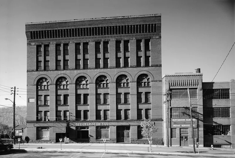
Huntingdon Borough's historic district occupies the southern end of the borough between the Juniata River and a steep hill, and holds about 521 buildings, most of them brick or frame, two and three stories tall. Founded as a proprietary town in 1766 by William Smith, it became county seat in 1787. Its position on the river, and on the turnpike completed in 1820, the Pennsylvania Canal reaching the town in 1832, and the Pennsylvania Railroad arriving in 1850, made it a busy stop for travelers and freight. The district's businesses formed the largest commercial center in Huntingdon County. Its architecture is notable for the number of nineteenth-century buildings, including Federal houses such as the Saxton House of 1840, Italianate buildings, and the Blair Building of 1889, once the tallest between Pittsburgh and Philadelphia. Most of the district's buildings date from 1820 to 1900, and the district is regarded as containing one of the best collections of such architecture in the county.
Significance in brief: The nomination argues the district was a historic center of commerce and transportation in central Pennsylvania, served by the turnpike, canal and railroad, and that it contains one of the finest groups of nineteenth-century architecture in the county. Its largest commercial center and many Federal, Italianate and Queen Anne buildings are cited as evidence.
Machine-generated summary. This summary was generated by a language model from the official nomination document and has not been reviewed line by line by an editor. It may contain errors. Check the source document before relying on any detail. Source: nomination document (PDF) · National Archives catalog entry. NRHP reference 86000852, listed April 24, 1986. Summary generated October 2026 (model claude-haiku-5-5, prompt v1.1-2026-10-29, confidence medium).
Key facts
| Address | Roughly bounded by Moore, Second, Allegheny, and Ninth Sts., Huntingdon |
|---|---|
| County | Huntingdon County |
| Listed | April 24, 1986 |
| Reference number | 86000852 |
| Resource type | District |
| Period of significance | 1788-1935 |
| Architectural style | Federal, Italianate, Queen Anne, with smaller numbers of Greek Revival, Colonial Revival, Second Empire, French Renaissance, Eastlake and Art Moderne buildings |
| Criteria |
|
| Areas of significance | Commerce, Transportation, Architecture |
| Level of significance | Local |
| Status (as stated in the nomination) | Good integrity; 492 of 521 buildings are contributing, and several outstanding examples of adaptive re-use are noted. |
| Acreage | 87 |
| Coordinates | 40.48658, -78.01169 (NPS GIS) |
What listing means for this property
This is a historic district. Buildings within its boundary are either contributing (they add to the district's significance) or non-contributing. Owners of contributing income-producing buildings can claim the 20% federal rehabilitation tax credit; homeowners should look at state credits. National Register districts impose no design review by themselves; a local historic district ordinance, if one exists, does (the difference explained).
General information, not legal or tax advice. Rules change; confirm with your State Historic Preservation Office or a qualified adviser.
Sources and further reading
- National Park Service, National Register of Historic Places database (snapshot May 2026), reference 86000852.
- Nomination form (PDF, National Archives) — catalog entry
- Wikipedia article (used for cross-checking only; text not reproduced here)
- Wikidata Q15226947
- This listing as JSON
Last updated October 2026. Found an error? See the editorial policy for how to report it.