Pulpit Rocks

Why it's listed
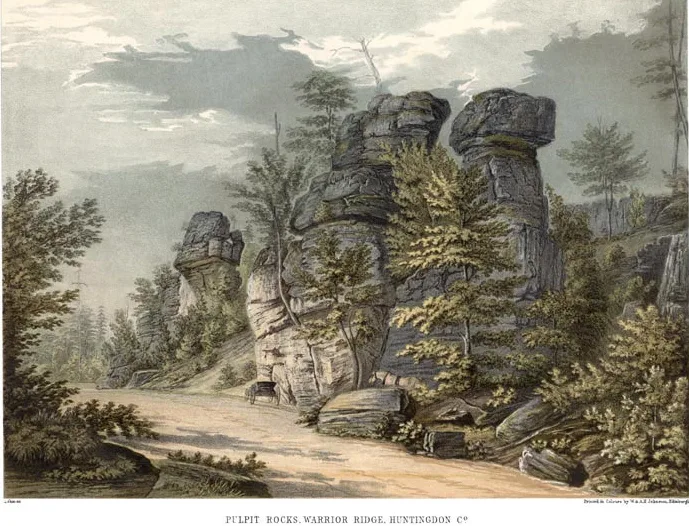
Pulpit Rocks is a group of weathered sandstone pillars on Warrior Ridge, about one and a half miles northwest of Huntingdon, Pennsylvania, beside the old Huntingdon-Hollidaysburg Turnpike. The rocks are remnants of the Oriskany, or Ridgeley, formation, deposited in an ancient sea nearly 390 million years ago. Juniata College owns most of the site, which was donated by the Africa family. The rocks appear in George Lehman's 1840 watercolor, which was used as the frontispiece to Henry D. Rogers's report on the First Geological Survey of Pennsylvania. In 1836, Rogers, James C. Booth and John F. Frazer met in Huntingdon and agreed on the order of the region's sedimentary rocks. That agreement is regarded as the basis for later geologic mapping across the Appalachians and the eastern United States. The site is still used for teaching geology.
Significance in brief: The nomination argues that the rocks illustrate the findings of the First Geological Survey of Pennsylvania, particularly the 1836 agreement on the order of succession of sedimentary rocks in central Pennsylvania. That agreement is said to have set the framework for later geologic work in the Appalachians and the eastern United States, and the survey is credited with founding structural geology. The site is also described as largely unchanged since the survey's time, retaining a high level of integrity.
Machine-generated summary. This summary was generated by a language model from the official nomination document and has not been reviewed line by line by an editor. It may contain errors. Check the source document before relying on any detail. Source: nomination document (PDF) · National Archives catalog entry. NRHP reference 93001614, listed November 4, 1993. Summary generated October 2026 (model claude-haiku-5-5, prompt v1.1-2026-10-29, confidence medium).
Key facts
| Address | Old Huntingdon--Hollidaysburg Tpk., Huntingdon |
|---|---|
| County | Huntingdon County |
| Listed | November 4, 1993 |
| Reference number | 93001614 |
| Resource type | Site |
| Period of significance | 1836-1842 |
| Criteria |
|
| Areas of significance | Science |
| Level of significance | National |
| National Historic Landmark | Yes, designated November 4, 1993 |
| Status (as stated in the nomination) | The primary use today is as an outdoor classroom for geology at Juniata College, and the deed requires the college to preserve the site in perpetuity. |
| Acreage | 4.5 |
| Coordinates | 40.51670, -78.04582 (NPS GIS) |
What listing means for this property
Sites (archaeological sites, battlefields, landscapes) are often listed with a restricted address to protect them from looting or disturbance. Listing is honorary for private owners; federal undertakings on or near the site go through Section 106 review, and state laws may protect burials and artefacts regardless of listing.
General information, not legal or tax advice. Rules change; confirm with your State Historic Preservation Office or a qualified adviser.
Sources and further reading
- National Park Service, National Register of Historic Places database (snapshot May 2026), reference 93001614.
- Nomination form (PDF, National Archives) — catalog entry
- Wikipedia article (used for cross-checking only; text not reproduced here)
- Wikidata Q7259599
- This listing as JSON
Last updated October 2026. Found an error? See the editorial policy for how to report it.