Dawson Historic District

The pin is a point inside the NPS boundary polygon, not a surveyed location.
Why it's listed
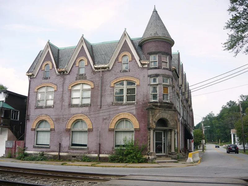
Dawson is a small borough of 120 buildings on a flood plain of the Youghiogheny River in Fayette County, Pennsylvania. Its streets hold frame and brick houses, commercial blocks and vernacular working-class dwellings built from about 1870 to 1947. The town grew from land settled by John Smilie in the late 1780s and was laid out by Alfred Howell in 1866 and 1871. It was incorporated in 1872. Dawson served as a residential and commercial centre for managers, miners and the Cochran family, whose Washington Coal and Coke Company operated nearby mines and a coke works. The population reached 668 in 1890 and about 1,800 by 1910. Its 1897 Queen Anne bank building, with a corner turret and slate mansard roof, and the 1927 Gothic Methodist church are among the most prominent buildings. Many houses retain original materials. The district reflects a town that combined elite houses and workers' homes side by side, unlike company patch towns.
Significance in brief: The district is significant for industry as a residential and commercial community for management, workers and the Cochran family during the bituminous coal and coke era. It is also significant for architecture as a vital river community whose variety of frame, brick and vernacular buildings, constructed between 1870 and 1947, reflects coal and coke prosperity. Most of its buildings survive from that period.
Machine-generated summary. This summary was generated by a language model from the official nomination document and has not been reviewed line by line by an editor. It may contain errors. Check the source document before relying on any detail. Source: nomination document (PDF) · National Archives catalog entry. NRHP reference 97001252, listed November 5, 1997. Summary generated October 2026 (model claude-haiku-5-5, prompt v1.1-2026-10-29, confidence medium).
Key facts
| Address | [Roughly bounded by Howell St., Middle Alley, Youghiogheny R, River Rd., and Spring, and Locust Alleys, Dawson |
|---|---|
| County | Fayette County |
| Listed | November 5, 1997 |
| Reference number | 97001252 |
| Resource type | District |
| Period of significance | 1870-1947 |
| Architect / builder | Thomas Pringle (architect, for the Methodist church) |
| Architectural style | Queen Anne, Classical Revival, Bungalow, Greek Revival, Italianate, Colonial Revival, Gothic, Art Moderne, vernacular |
| Criteria |
|
| Areas of significance | Industry, Architecture |
| Level of significance | Local |
| Status (as stated in the nomination) | Twelve of the 120 buildings are non-contributing; the document describes the architectural fabric as largely intact. |
| Acreage | 35.5 |
| Coordinates | 40.04753, -79.66010 (NPS GIS) |
What listing means for this property
This is a historic district. Buildings within its boundary are either contributing (they add to the district's significance) or non-contributing. Owners of contributing income-producing buildings can claim the 20% federal rehabilitation tax credit; homeowners should look at state credits. National Register districts impose no design review by themselves; a local historic district ordinance, if one exists, does (the difference explained).
General information, not legal or tax advice. Rules change; confirm with your State Historic Preservation Office or a qualified adviser.
Sources and further reading
- National Park Service, National Register of Historic Places database (snapshot May 2026), reference 97001252.
- Nomination form (PDF, National Archives) — catalog entry
- Wikipedia article (used for cross-checking only; text not reproduced here)
- Wikidata Q5242664
- This listing as JSON
Last updated October 2026. Found an error? See the editorial policy for how to report it.