Jefferson Land Association Historic District

Why it's listed
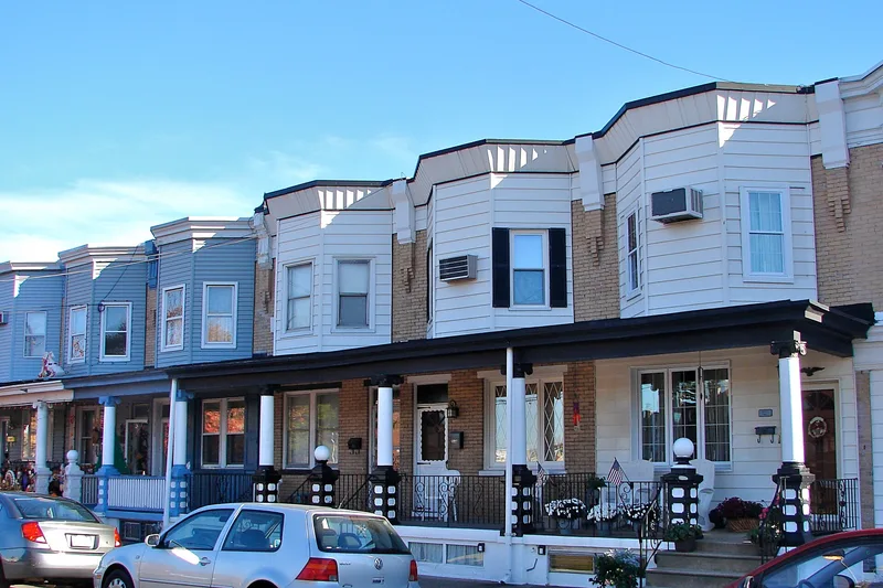
Bristol's northern edge holds five blocks of brick rowhouses and five corner commercial buildings, all put up in 1917 and 1918 on land the Jefferson Land Association had owned since the 1890s. The rows are two stories high under flat roofs, with golden Roman brick on the front facades and a single continuous porch across each block supported by concrete Ionic columns. Each house has a three-sided second-story bay, and the three flatiron-shaped corner buildings lack the porches and bays. Most of the buildings have had their bays re-sided and some cornices boxed in, but the group still reads as one composition. The district is significant as a privately financed response to the worker housing shortage that followed the mobilization of local mills and factories for wartime production. Its single-developer, block-long construction contrasted sharply with the small-scale housing typical of the town.
Significance in brief: The district is argued to be an unusual local response to working-class housing needs created by wartime industrial expansion after the United States entered World War I. Its uniform, block-long rows and bay-and-porch detailing depart from Bristol's usual single-family, duplex and small-row housing, and it is one of only two large residential developments in Bristol built for that purpose, the other being government-built housing at Harriman.
Machine-generated summary. This summary was generated by a language model from the official nomination document and has not been reviewed line by line by an editor. It may contain errors. Check the source document before relying on any detail. Source: nomination document (PDF) · National Archives catalog entry. NRHP reference 87001994, listed November 5, 1987. Summary generated October 2026 (model claude-haiku-5-5, prompt v1.1-2026-10-29, confidence high).
Key facts
| Address | Bounded by Spring St., Jefferson Ave., Garden & Mansion Sts., & Beaver Dam Rd., Bristol |
|---|---|
| County | Bucks County |
| Listed | November 5, 1987 |
| Reference number | 87001994 |
| Resource type | District |
| Period of significance | 1917-1918 |
| Criteria |
|
| Areas of significance | Architecture |
| Level of significance | Local |
| Acreage | 6.6 |
| Coordinates | 40.10681, -74.85435 (NPS GIS) |
What listing means for this property
This is a historic district. Buildings within its boundary are either contributing (they add to the district's significance) or non-contributing. Owners of contributing income-producing buildings can claim the 20% federal rehabilitation tax credit; homeowners should look at state credits. National Register districts impose no design review by themselves; a local historic district ordinance, if one exists, does (the difference explained).
General information, not legal or tax advice. Rules change; confirm with your State Historic Preservation Office or a qualified adviser.
Sources and further reading
- National Park Service, National Register of Historic Places database (snapshot May 2026), reference 87001994.
- Nomination form (PDF, National Archives) — catalog entry
- Wikipedia article (used for cross-checking only; text not reproduced here)
- Wikidata Q6175521
- This listing as JSON
Last updated October 2026. Found an error? See the editorial policy for how to report it.