Detroit-Superior High Level Bridge

Why it's listed
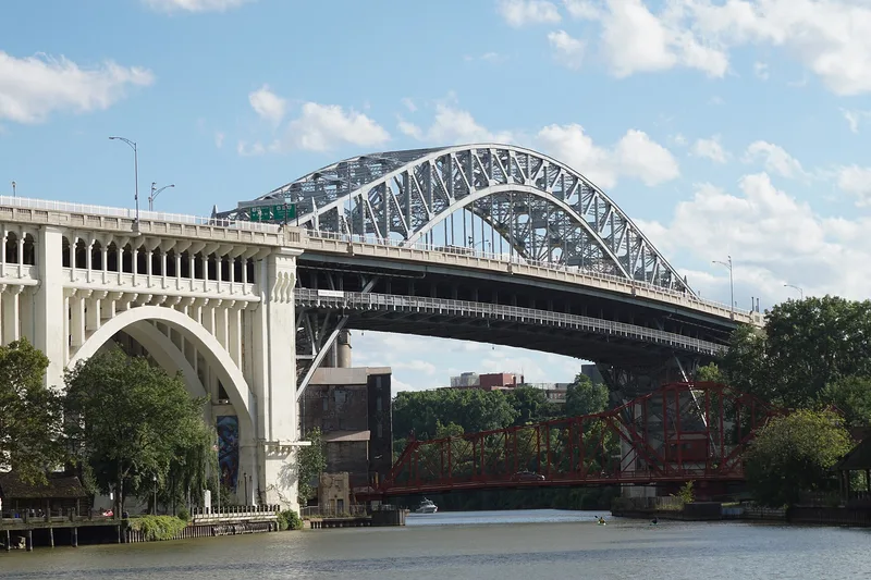
Spanning the Cuyahoga River Valley between Detroit Avenue and Superior Avenue, this double-deck bridge links the two halves of central Cleveland. It is 2,656 feet long, or 3,112 feet with approaches, and its roadways rest on twelve reinforced concrete arches anchored in four large concrete piers. The central span over the river hangs from a steel arch 591 feet wide and 196 feet above the water. Completed in 1917 and designed by county engineers A. B. Lea and Frank R. Lander, it cost $5,407,000. The upper level carried road traffic and the lower level streetcars, the first of which crossed on December 24, 1917. At completion it was the largest double-deck reinforced concrete bridge in the world, and it helped unify a city divided by the valley. Its design is valued for functional simplicity and as an expression of contemporary concrete technology. A 1967 widening added a lane on each side, leaving six lanes on the upper roadway.
Significance in brief: When completed in 1917 it was the largest double-deck reinforced concrete bridge in the world. It helped unify a city divided by the river valley. Its design shows functional simplicity and an excellent expression of the reinforced concrete technology of its time, with a long central steel span that was remarkable for its date.
Machine-generated summary. This summary was generated by a language model from the official nomination document and has not been reviewed line by line by an editor. It may contain errors. Check the source document before relying on any detail. Source: nomination document (PDF) · National Archives catalog entry. NRHP reference 74001437, listed January 18, 1974. Summary generated October 2026 (model claude-sonnet-5-5, prompt v1.0-2026-10-29, confidence medium).
Key facts
| Address | Over Cuyahoga River Valley, between Detroit Ave. and Superior Ave., Cleveland |
|---|---|
| County | Cuyahoga County |
| Listed | January 18, 1974 |
| Reference number | 74001437 |
| Resource type | Structure |
| Period of significance | 20th Century; specific dates 1917, 1967 |
| Architect / builder | A. B. Lea and Frank R. Lander, county engineers |
| Areas of significance | Engineering, Transportation |
| Level of significance | Local |
| Status (as stated in the nomination) | Listed in excellent condition and altered; in 1967 an additional lane was added on each side, so the upper roadway carries six lanes of modern traffic. Marked occupied and open to the public without restriction, with transportation as its use. |
| Acreage | 5.4 |
| Within district | Cleveland Centre Historic District |
| Coordinates | 41.49420, -81.70236 (NPS GIS) |
What listing means for this property
For a publicly owned building or structure, listing mainly matters when federal funds, permits or licences are involved: projects then go through Section 106 review so effects on the property are considered. Listing also strengthens applications for preservation grants and, for leased income-producing uses, can enable the federal rehabilitation tax credit.
General information, not legal or tax advice. Rules change; confirm with your State Historic Preservation Office or a qualified adviser.
Sources and further reading
- National Park Service, National Register of Historic Places database (snapshot May 2026), reference 74001437.
- Nomination form (PDF, National Archives) — catalog entry
- Wikipedia article (used for cross-checking only; text not reproduced here)
- Wikidata Q2493242
- This listing as JSON
Last updated October 2026. Found an error? See the editorial policy for how to report it.