Halifax Historic District
Also known as: Halifax
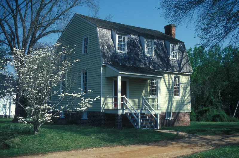

Why it's listed
Halifax was a planned colonial river town on the Roanoke, chartered in 1757 and laid out in 1758 on a grid running perpendicular to the river. It grew into a major center of trade, courts and politics, with taverns, warehouses and more than sixty substantial houses. Here the Fourth Provincial Congress adopted the Halifax Resolves in April 1776, and the Fifth Provincial Congress drafted North Carolina's first constitution that December. After the Revolution the town declined as the population moved west and the railroad bypassed it. Today most of the old town site is lawn or woodland, and four historic buildings remain: the Constitution House (ca. 1770), the Owens House (ca. 1760), the Clerk's Office (ca. 1832) and the Jail (ca. 1838). The district is also valued for its archaeological potential, which allows study of how material culture changed in a stable early American town.
Significance in brief: Halifax was a leading political, social and commercial center of colonial North Carolina. It was the site of the adoption of the Halifax Resolves on April 12, 1776 and the drafting of the state's first constitution later that year. The surviving buildings and the archaeological remains also offer a chance to study cultural change in a stable colonial and early-republic town.
Machine-generated summary. This summary was generated by a language model from the official nomination document and has not been reviewed line by line by an editor. It may contain errors. Check the source document before relying on any detail. Source: nomination document (PDF) · National Archives catalog entry. NRHP reference 70000456, listed January 21, 1970. Summary generated October 2026 (model claude-sonnet-5-5, prompt v1.0-2026-10-29, confidence high).
Key facts
| Address | Roughly bounded by St. David St., Owens House Drainage Ditch, Roanoke River, and Magazine Spring Gut, Halifax |
|---|---|
| County | Halifax County |
| Listed | January 21, 1970 |
| Reference number | 70000456 |
| Resource type | District |
| Period of significance | 18th and 19th centuries |
| Architectural style | Gambrel-roofed 18th-century house; Gothic/Romantic Revival (Clerk's Office); plain frame and brick public buildings |
| Areas of significance | Commerce, Politics/Government, Architecture |
| Level of significance | National |
| Status (as stated in the nomination) | Condition marked fair and altered. Almost all historic structures have been lost above ground; four survive, and the site was being developed by the State as a historic site. Some non-historic private residences were being removed. |
| Acreage | 50 |
| Coordinates | 36.33251, -77.58748 (NPS GIS) |
What listing means for this property
This is a historic district. Buildings within its boundary are either contributing (they add to the district's significance) or non-contributing. Owners of contributing income-producing buildings can claim the 20% federal rehabilitation tax credit; homeowners should look at state credits. National Register districts impose no design review by themselves; a local historic district ordinance, if one exists, does (the difference explained).
General information, not legal or tax advice. Rules change; confirm with your State Historic Preservation Office or a qualified adviser.
Sources and further reading
- National Park Service, National Register of Historic Places database (snapshot May 2026), reference 70000456.
- Nomination form (PDF, National Archives) — catalog entry
- Wikipedia article (used for cross-checking only; text not reproduced here)
- Wikidata Q5642189
- This listing as JSON
Last updated October 2026. Found an error? See the editorial policy for how to report it.