Daniels, John T., House

Why it's listed
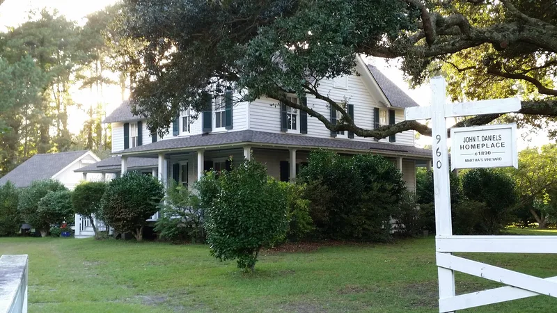
Built between 1897 and 1900 on Burnside Road, west of downtown Manteo, this two-story weatherboarded house is a well-preserved example of the I-house form common on Roanoke Island. It has a center-hall plan one room deep, a two-story rear ell, shaped rafter ends, two-over-two windows and beaded board interiors. Large live oaks, a grape arbor, yaupons and camellias surround it on an eight-acre lot. Its first owner, John T. Daniels, worked as a ferry tender, boat mechanic and U.S. Life-Saving Service surfman. He helped the Wright brothers at Kill Devil Hills and took the well-known photograph of their first flight on December 17, 1903. The house was listed for architecture, as an increasingly rare intact homeplace in an area where many period houses and farmsteads have been altered, divided or lost. A restoration in 1999-2000 removed aluminum siding and reinstated a cedar shake roof. A former kitchen shed survives beside it.
Significance in brief: The nomination argues the house is an intact example of a simple Queen Anne-influenced I-house with a two-story rear ell, typical of homes built by Roanoke Island fishermen and U.S. Life-Saving Service surfmen. Its shade oaks and period plantings preserve the character of an early twentieth-century island farmstead. Daniels is also noted for photographing the Wright brothers' first flight in 1903.
Machine-generated summary. This summary was generated by a language model from the official nomination document and has not been reviewed line by line by an editor. It may contain errors. Check the source document before relying on any detail. Source: nomination document (PDF) · National Archives catalog entry. NRHP reference 03000339, listed May 1, 2003. Summary generated October 2026 (model claude-sonnet-5-5, prompt v1.0-2026-10-29, confidence high).
Key facts
| Address | 960 Burnside Rd., Manteo |
|---|---|
| County | Dare County |
| Listed | May 1, 2003 |
| Reference number | 03000339 |
| Resource type | Building |
| Period of significance | ca. 1900 |
| Architectural style | Queen Anne; Other: Traditional I-House |
| Criteria |
|
| Areas of significance | Architecture |
| Level of significance | Local |
| Status (as stated in the nomination) | Restored 1999-2000, when aluminum siding was removed and a cedar shake roof installed; still used as a single dwelling. |
| Acreage | 8.2 |
| Coordinates | 35.90700, -75.68294 (NPS GIS) |
What listing means for this property
National Register listing is honorary for a privately owned home: it does not by itself restrict what an owner may do with their own money, and it does not require public access. Restrictions come from local landmark or historic-district ordinances, which are separate (how they differ).
Owner-occupied houses are not eligible for the 20% federal rehabilitation tax credit, which applies to income-producing buildings, but many states offer credits for homeowners. Listing also opens the door to preservation easements and to buying a plaque. Start with what listing means for homeowners, renovating a listed house and selling one.
General information, not legal or tax advice. Rules change; confirm with your State Historic Preservation Office or a qualified adviser.
Sources and further reading
- National Park Service, National Register of Historic Places database (snapshot May 2026), reference 03000339.
- Nomination form (PDF, National Archives) — catalog entry
- Wikipedia article (used for cross-checking only; text not reproduced here)
- Wikidata Q18206296
- This listing as JSON
Last updated October 2026. Found an error? See the editorial policy for how to report it.