Poppletown Farmhouse

Why it's listed
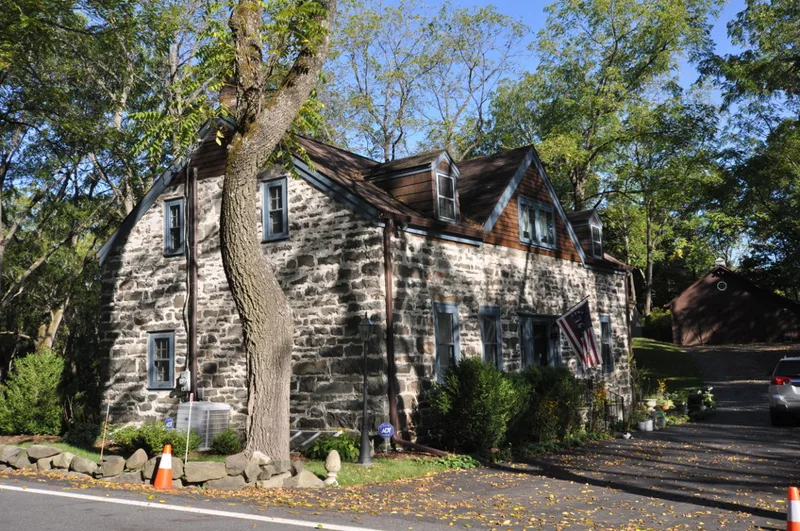
Built around 1800 near the Hudson River in Esopus, this rubble stone farmhouse is a five-bay, one-and-one-half story dwelling with a gable roof and center hall plan. It sits at Old Post Road and Swarte Kill Road on 4.4 acres, all that remains of a 120-acre mountainside farm known as Poppletown. The land passed into the hands of John Beaver Jr. through purchases between 1802 and 1804, and the Beaver family kept the farm until 1867. The house is valued as a well-preserved example of Ulster County stone farmhouse building. It keeps the region's long tradition of stone walls and compact massing, yet adds a strictly symmetrical facade, a Federal-style entrance with fluted pilasters and sidelights, and more refined woodwork in the parlor. The kitchen was placed in the basement, and the formal parlor became the main room. Early twentieth-century dormers and a cross-gable were added, but the building remains largely intact.
Significance in brief: The nomination argues the house is a highly intact, distinctive example of vernacular stone domestic architecture in Ulster County. It blends the traditional stone-house form with Federal and Neoclassical features such as a symmetrical facade, center hall plan and molded wooden entrance with sidelights. It documents how regional stone house design changed in the late eighteenth and early nineteenth centuries.
Machine-generated summary. This summary was generated by a language model from the official nomination document and has not been reviewed line by line by an editor. It may contain errors. Check the source document before relying on any detail. Source: nomination document (PDF) · National Archives catalog entry. NRHP reference 91001656, listed November 7, 1991. Summary generated October 2026 (model claude-sonnet-5-5, prompt v1.0-2026-10-29, confidence high).
Key facts
| Address | Jct. of Old Post Rd. and Swarte Kill Rd., Esopus |
|---|---|
| County | Ulster County |
| Listed | November 7, 1991 |
| Reference number | 91001656 |
| Resource type | Building |
| Period of significance | c. 1802 |
| Architect / builder | Unknown |
| Architectural style | Colonial/Dutch Colonial; Early Republic/Federal |
| Areas of significance | Architecture |
| Level of significance | Local |
| Status (as stated in the nomination) | Retains a high degree of physical integrity and remains in use as a single dwelling; four mid-twentieth-century outbuildings on the lot are non-contributing, and most are in ruinous condition except a modernized garage. |
| Acreage | 4.4 |
| Coordinates | 41.82121, -73.97480 (NPS GIS) |
What listing means for this property
National Register listing is honorary: it recognises significance and does not restrict what a private owner may do without federal money or permits. It unlocks the 20% federal rehabilitation tax credit for income-producing buildings, state credits in many states, and Section 106 review when federal agencies are involved. See what listing means in practice.
General information, not legal or tax advice. Rules change; confirm with your State Historic Preservation Office or a qualified adviser.
Sources and further reading
- National Park Service, National Register of Historic Places database (snapshot May 2026), reference 91001656.
- Nomination form (PDF, National Archives) — catalog entry
- Wikipedia article (used for cross-checking only; text not reproduced here)
- Wikidata Q7229550
- This listing as JSON
Last updated October 2026. Found an error? See the editorial policy for how to report it.