Pearl Street Schoolhouse

Why it's listed
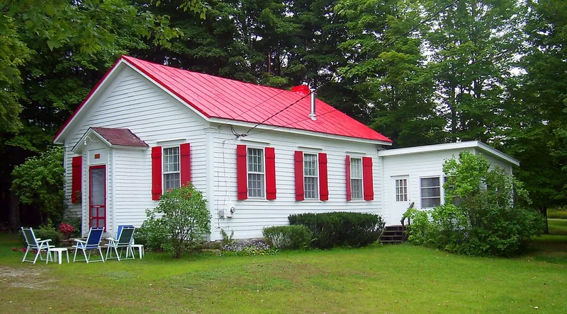
Built around 1850 at the corner of Awosting and Decker Roads in Shawangunk, this one-room frame schoolhouse measures thirty by thirty-four feet. It has a gabled standing-seam metal roof, a brick end chimney, 12/12 double-hung windows, corner pilasters and a projecting entrance with a diagonally planked, beaded door. The land was donated to the town by the Jansen family, and the name Pearl Street probably reflects the family's ties to Pearl Street in New York City. An 1875 atlas lists it as Public School #11. It served as a school until 1942-43, when Jansen heirs sold it. The interior was divided in 1953 and rear additions followed in 1956 and 1965, yet wainscotting, cupboards, coat pegs and a stove mark survive. It was listed as a rare pre-Civil War school and the only public building in its multiple resource area.
Significance in brief: It is described as a rare surviving pre-Civil War school building in the Shawangunk Valley multiple resource area and the only public building included in it. It keeps almost complete integrity of form and detail despite conversion to a house, and it marks the community's development.
Machine-generated summary. This summary was generated by a language model from the official nomination document and has not been reviewed line by line by an editor. It may contain errors. Check the source document before relying on any detail. Source: nomination document (PDF) · National Archives catalog entry. NRHP reference 83001820, listed September 26, 1983. Summary generated October 2026 (model claude-sonnet-5-5, prompt v1.0-2026-10-29, confidence medium).
Key facts
| Address | Awosting and Decker Rds., Shawangunk |
|---|---|
| County | Ulster County |
| Listed | September 26, 1983 |
| Reference number | 83001820 |
| Resource type | Building |
| Areas of significance | Architecture |
| Level of significance | Local |
| Status (as stated in the nomination) | Used as a school until 1942-43, now a residence in good condition; a noncontributing shed and the remains of an old well are on the 1.5-acre parcel. |
| Acreage | 1.5 |
| Coordinates | 41.65607, -74.27660 (NPS GIS) |
What listing means for this property
For a publicly owned building or structure, listing mainly matters when federal funds, permits or licences are involved: projects then go through Section 106 review so effects on the property are considered. Listing also strengthens applications for preservation grants and, for leased income-producing uses, can enable the federal rehabilitation tax credit.
General information, not legal or tax advice. Rules change; confirm with your State Historic Preservation Office or a qualified adviser.
Sources and further reading
- National Park Service, National Register of Historic Places database (snapshot May 2026), reference 83001820.
- Nomination form (PDF, National Archives) — catalog entry
- Wikipedia article (used for cross-checking only; text not reproduced here)
- Wikidata Q7158175
- This listing as JSON
Last updated October 2026. Found an error? See the editorial policy for how to report it.