Tusten Stone Arch Bridge

Why it's listed
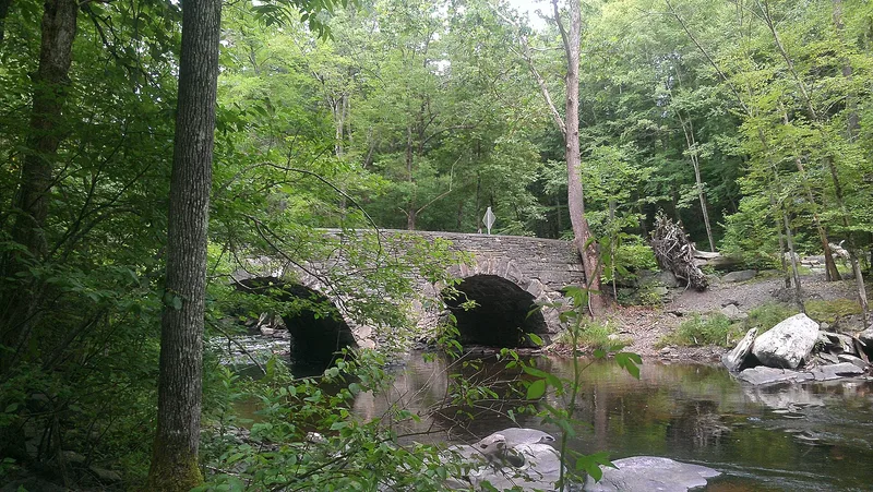
Built in 1896, this two-arch stone bridge carries Tusten Road over the Ten Mile River close to where it meets the Delaware. It measures 51.5 feet long and about 15 feet wide, with arches of mortared voussoirs springing from bedrock, a center pier shaped as an icebreaker, fieldstone walls, and bluestone coping. A coping stone recovered from the river names the builder, W.H. Hankins & Co., and the date. Hankins, a raftsman and stone mason, ran quarries employing up to 30 men. The bridge stood at the heart of the mill hamlet of Tusten and linked its northern and southern halves. It was listed as one of only two surviving stone arch bridges in the Upper Delaware corridor and for its intact traditional construction. Through traffic moved to Route 97 in 1939, but the bridge still serves local traffic and Scouts hiking to camps. Little else of the hamlet survives.
Significance in brief: The bridge is argued to be a rare, intact example of traditional stone arch bridge construction in the Upper Delaware Valley, one of only two surviving in the 74-mile river corridor. It is also significant as part of Tusten's infrastructure, linking the northern and southern halves of the former milling community. It remains in its original use and retains a high degree of integrity.
Machine-generated summary. This summary was generated by a language model from the official nomination document and has not been reviewed line by line by an editor. It may contain errors. Check the source document before relying on any detail. Source: nomination document (PDF) · National Archives catalog entry. NRHP reference 00000839, listed July 27, 2000. Summary generated October 2026 (model claude-sonnet-5-5, prompt v1.0-2026-10-29, confidence high).
Key facts
| Address | Tusten Rd. at Ten Mile River, Tusten |
|---|---|
| County | Sullivan County |
| Listed | July 27, 2000 |
| Reference number | 00000839 |
| Resource type | Structure |
| Period of significance | 1896 |
| Architect / builder | Hankins, William H. and Co., Tusten, NY |
| Architectural style | OTHER / stone arch bridge |
| Criteria |
|
| Areas of significance | Architecture, Transportation, Community Planning and Development |
| Level of significance | Local |
| Status (as stated in the nomination) | Unaltered, in fair condition, and still in use as a vehicular bridge on unpaved roads; owned by the Town of Tusten and surrounded by Boy Scout camping land. |
| Acreage | 0.9 |
| Coordinates | 41.55616, -75.01906 (NPS GIS) |
What listing means for this property
For a publicly owned building or structure, listing mainly matters when federal funds, permits or licences are involved: projects then go through Section 106 review so effects on the property are considered. Listing also strengthens applications for preservation grants and, for leased income-producing uses, can enable the federal rehabilitation tax credit.
General information, not legal or tax advice. Rules change; confirm with your State Historic Preservation Office or a qualified adviser.
Sources and further reading
- National Park Service, National Register of Historic Places database (snapshot May 2026), reference 00000839.
- Nomination form (PDF, National Archives) — catalog entry
- Wikipedia article (used for cross-checking only; text not reproduced here)
- Wikidata Q7856842
- This listing as JSON
Last updated October 2026. Found an error? See the editorial policy for how to report it.