New Dorp Light
Also known as: Moravian Light

Why it's listed
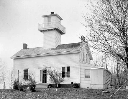
New Dorp Light, also called the Moravian Light, is a lighthouse on high ground at New Dorp Heights on Staten Island, overlooking the Verrazano Narrows and lower New York Bay. Built around 1854 for the Federal Lighthouse Service, it combines a two-story clapboarded frame dwelling on a brick foundation with a short square tower rising from the center of the gable roof. A cantilevered balcony circles the tower room, and a low pyramidal roof carries the beacon, which showed a steady light rather than a flashing one. A small wing with a covered porch was added at the entrance. The design was a departure from the usual tall cylindrical tower, and the house let the keeper live close to the light. It is described as a rare surviving example of the plain, low-cost lighthouses built when the federal government kept expenses down. The Coast Guard acquired it in 1939 and operated it until 1964. It was designated a New York City landmark before national listing.
Significance in brief: The nomination calls it a rare remaining example of a simple, economy-minded lighthouse design once common in New York State, with a rectangular tower rising through the house roof instead of the typical tall cylindrical tower. It is also ranked as a local landmark for its long service as a navigational beacon over the Verrazano Narrows and lower New York Bay.
Machine-generated summary. This summary was generated by a language model from the official nomination document and has not been reviewed line by line by an editor. It may contain errors. Check the source document before relying on any detail. Source: nomination document (PDF) · National Archives catalog entry. NRHP reference 73001260, listed August 28, 1973. Summary generated October 2026 (model claude-sonnet-5-5, prompt v1.0-2026-10-29, confidence medium).
Key facts
| Address | Altamont Ave., Staten Island, New York |
|---|---|
| County | Staten Island |
| Listed | August 28, 1973 |
| Reference number | 73001260 |
| Resource type | Building |
| Period of significance | 19th Century (specific date 1854) |
| Areas of significance | Architecture |
| Level of significance | Local |
| Status (as stated in the nomination) | Coast Guard operated it from 1939 until it passed out of active use in 1964; later declared excess and awaiting disposal by the General Services Administration. Form lists condition as altered, on original site, and use as unoccupied. |
| Acreage | 0.9 |
| Coordinates | 40.57598, -74.14114 (NPS GIS) |
What listing means for this property
National Register listing is honorary: it recognises significance and does not restrict what a private owner may do without federal money or permits. It unlocks the 20% federal rehabilitation tax credit for income-producing buildings, state credits in many states, and Section 106 review when federal agencies are involved. See what listing means in practice.
Noted as vacant in the nomination. Nomination documents can be decades old; current status may differ. If you are considering buying an empty listed property, read the due-diligence checklist.
General information, not legal or tax advice. Rules change; confirm with your State Historic Preservation Office or a qualified adviser.
Sources and further reading
- National Park Service, National Register of Historic Places database (snapshot May 2026), reference 73001260.
- Nomination form (PDF, National Archives) — catalog entry
- Wikipedia article (used for cross-checking only; text not reproduced here)
- Wikidata Q1796230
- This listing as JSON
Last updated October 2026. Found an error? See the editorial policy for how to report it.