Battery Weed

Why it's listed
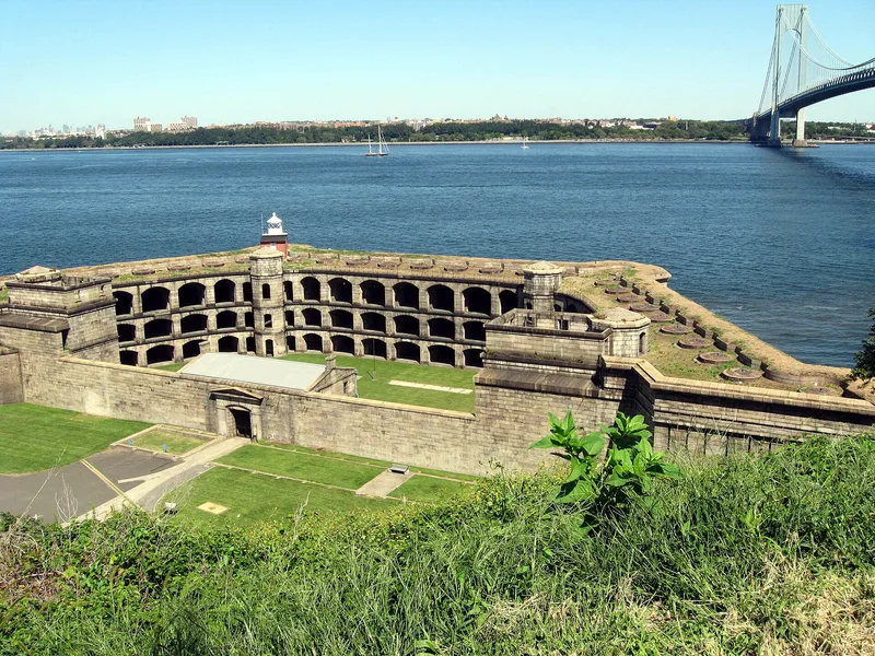
Battery Weed is a granite fort on the shore of the Narrows at Fort Wadsworth, Staten Island. Begun in 1847 after the site passed from New York State to federal control, it was completed in fourteen years, and troops first garrisoned it on August 8, 1861. The fort is a trapezoid with walls of solid granite slabs up to six feet thick at the sea wall. Three sides face an inner courtyard and rise three stories, framed by tiers of segmental arches forming galleries, with octagonal stair towers in the corners. A two-story gatehouse sits at the center of the low land-side wall. Masons cut and set the blocks so precisely that little mortar was needed. In 1862 the fort mounted between 140 and 150 cannon. It was named for Brigadier General Stephen H. Weed, killed at Gettysburg. Together with Fort Wadsworth, it forms what the nomination calls the oldest continually manned military position in the United States.
Significance in brief: The nomination presents it as an important example of military architecture of the second half of the 19th century. Its granite walls were laid with very little mortar thanks to the skill of the masons. It also forms part of the oldest continually manned military position in the United States, together with Fort Wadsworth.
Machine-generated summary. This summary was generated by a language model from the official nomination document and has not been reviewed line by line by an editor. It may contain errors. Check the source document before relying on any detail. Source: nomination document (PDF) · National Archives catalog entry. NRHP reference 72000908, listed January 20, 1972. Summary generated October 2026 (model claude-sonnet-5-5, prompt v1.0-2026-10-29, confidence medium).
Key facts
| Address | Fort Wadsworth Reservation, New York |
|---|---|
| County | Staten Island |
| Listed | January 20, 1972 |
| Reference number | 72000908 |
| Resource type | Building |
| Period of significance | 1847-1861 |
| Areas of significance | Military, Architecture |
| Level of significance | State |
| Status (as stated in the nomination) | Condition is marked excellent and unaltered, on its original site; ownership is listed as the US Department of Defense and present use as military. |
| Acreage | 0.9 |
| Coordinates | 40.60539, -74.05424 (NPS GIS) |
What listing means for this property
National Register listing is honorary: it recognises significance and does not restrict what a private owner may do without federal money or permits. It unlocks the 20% federal rehabilitation tax credit for income-producing buildings, state credits in many states, and Section 106 review when federal agencies are involved. See what listing means in practice.
General information, not legal or tax advice. Rules change; confirm with your State Historic Preservation Office or a qualified adviser.
Sources and further reading
- National Park Service, National Register of Historic Places database (snapshot May 2026), reference 72000908.
- Nomination form (PDF, National Archives) — catalog entry
- Wikipedia article (used for cross-checking only; text not reproduced here)
- Wikidata Q2178916
- This listing as JSON
Last updated October 2026. Found an error? See the editorial policy for how to report it.