Thirty Mile Point Light

Why it's listed
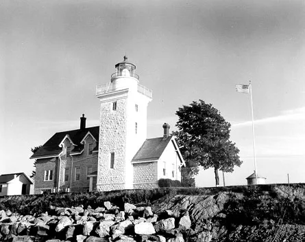
Thirty Mile Point Light is a lake-coast lighthouse on the Lake Ontario shore in Somerset, Niagara County, New York. Congress appropriated $30,000 in 1873 for a light at or near Thirty Mile Point to guide ships bound for the Welland Canal. Ground was broken in April 1875, and the grey limestone tower and attached dwelling were finished in January 1876. A flashing white light of the third order first shone on 27 April 1876. The 61-foot tower rises from the north face of a two-story Stick-Style keepers' dwelling that housed the keeper and an assistant. The dwelling was partly remodeled in 1934, when a new brick wing replaced the kitchen wing. Its interior is largely intact. Outbuildings include two round iron oil houses, a barn, a woodshed, a privy and a yellow brick fog-signal house from about 1935. A steel skeleton tower replaced the light in 1959. The station is valued for its role in Great Lakes shipping and as one of the oldest lighthouses of its type.
Significance in brief: The inventory states the lighthouse is significant in the development of Great Lakes shipping and is among the oldest of its kind. It was established to guide ships heading for the Welland Canal. The station retains its tower, dwelling and several outbuildings.
Machine-generated summary. This summary was generated by a language model from the official nomination document and has not been reviewed line by line by an editor. It may contain errors. Check the source document before relying on any detail. Source: nomination document (PDF) · National Archives catalog entry. NRHP reference 84003922, listed July 19, 1984. Summary generated October 2026 (model claude-sonnet-5-5, prompt v1.0-2026-10-29, confidence medium).
Key facts
| Address | Niagara River, Somerset |
|---|---|
| County | Niagara County |
| Listed | July 19, 1984 |
| Reference number | 84003922 |
| Resource type | District |
| Architectural style | Stick-Style (keepers' dwelling) |
| Areas of significance | Commerce, Engineering, Transportation |
| Level of significance | State |
| Status (as stated in the nomination) | Lens and lighting apparatus removed; superseded in 1959 by a steel skeleton tower; some vandalism from attempted entry; listed as deteriorating, with present use given as none. |
| Acreage | 1.5 |
| Coordinates | 43.37476, -78.48614 (NPS GIS) |
What listing means for this property
This is a historic district. Buildings within its boundary are either contributing (they add to the district's significance) or non-contributing. Owners of contributing income-producing buildings can claim the 20% federal rehabilitation tax credit; homeowners should look at state credits. National Register districts impose no design review by themselves; a local historic district ordinance, if one exists, does (the difference explained).
General information, not legal or tax advice. Rules change; confirm with your State Historic Preservation Office or a qualified adviser.
Sources and further reading
- National Park Service, National Register of Historic Places database (snapshot May 2026), reference 84003922.
- Nomination form (PDF, National Archives) — catalog entry
- Wikipedia article (used for cross-checking only; text not reproduced here)
- Wikidata Q7785223
- This listing as JSON
Last updated October 2026. Found an error? See the editorial policy for how to report it.