Route 29 Stone Arch Bridge

Why it's listed
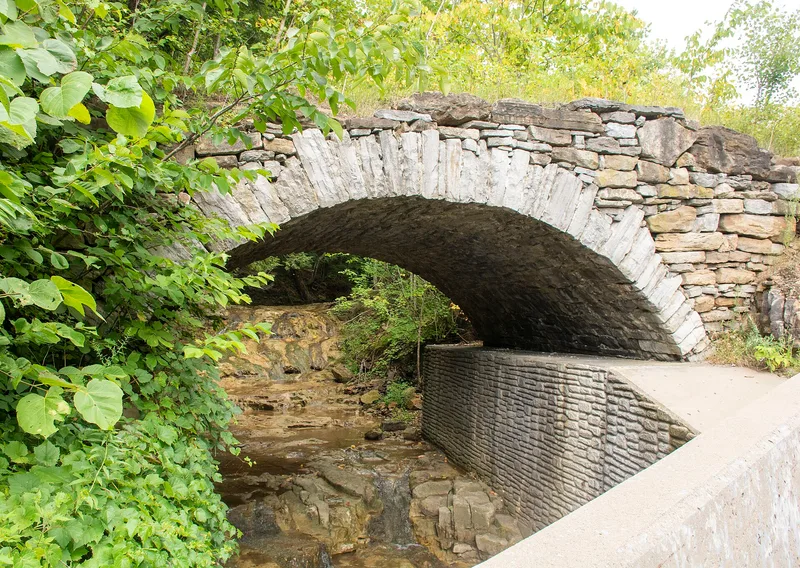
About a mile east of Middleville, in the town of Fairfield, a single-span limestone arch bridge crosses the south branch of Maltanner Creek. Built around 1870, it carried a wagon road between Middleville and Fairfield. The 35-foot-long structure has a segmental arch of mortared, partly dressed limestone voussoirs, with dry-laid fieldstone spandrels and abutments. Low fieldstone parapets once lined the roadway, and parts of them still stand in a collapsed state. Local tradition credits members of the Todd family of stone masons, though town records name no builder. The bridge was taken out of service in 1913, and the highway built in the 1920s followed a new alignment, which helped the old span survive. It is regarded as a rare, largely intact example of local vernacular engineering, one of only four of its type left in Fairfield, and one of the few stone bridges to withstand the August 1898 flood in the West Canada Creek valley.
Significance in brief: The bridge is significant under criteria A and C as a rare and substantially intact example of rural vernacular stone bridge design and construction. It is one of only four surviving examples of its type in the town of Fairfield. It reflects local transportation history and the work of local craftsmen using native limestone, and it survived the severe flood of August 1898.
Machine-generated summary. This summary was generated by a language model from the official nomination document and has not been reviewed line by line by an editor. It may contain errors. Check the source document before relying on any detail. Source: nomination document (PDF) · National Archives catalog entry. NRHP reference 00001685, listed January 26, 2001. Summary generated October 2026 (model claude-sonnet-5-5, prompt v1.0-2026-10-29, confidence high).
Key facts
| Address | NY 29, Middleville |
|---|---|
| County | Herkimer County |
| Listed | January 26, 2001 |
| Reference number | 00001685 |
| Resource type | Structure |
| Period of significance | ca. 1870-1913 |
| Architect / builder | Charles & Eugene Todd (builders-attributed) |
| Architectural style | No Style |
| Criteria |
|
| Areas of significance | Transportation, Engineering |
| Level of significance | Local |
| Status (as stated in the nomination) | Vacant and not in use; bypassed and removed from service in 1913, with portions of the fieldstone parapets partially collapsed. |
| Acreage | 0.9 |
| Coordinates | 43.13757, -74.94924 (NPS GIS) |
What listing means for this property
For a publicly owned building or structure, listing mainly matters when federal funds, permits or licences are involved: projects then go through Section 106 review so effects on the property are considered. Listing also strengthens applications for preservation grants and, for leased income-producing uses, can enable the federal rehabilitation tax credit.
Noted as vacant in the nomination. Nomination documents can be decades old; current status may differ. If you are considering buying an empty listed property, read the due-diligence checklist.
General information, not legal or tax advice. Rules change; confirm with your State Historic Preservation Office or a qualified adviser.
Sources and further reading
- National Park Service, National Register of Historic Places database (snapshot May 2026), reference 00001685.
- Nomination form (PDF, National Archives) — catalog entry
- Wikipedia article (used for cross-checking only; text not reproduced here)
- Wikidata Q7371415
- This listing as JSON
Last updated October 2026. Found an error? See the editorial policy for how to report it.