Linden Square

Why it's listed
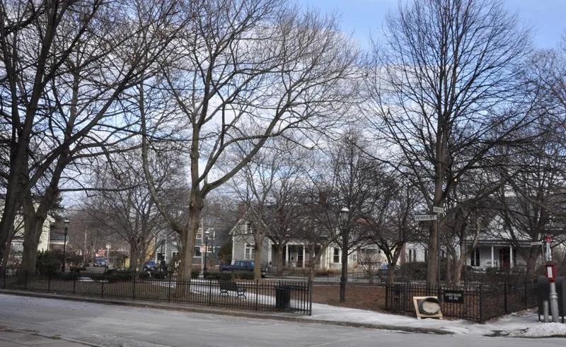
Linden Square is a small, flat, triangular park in Brookline Village, covering less than an acre. It was set aside in 1843-44 when Thomas Aspinwall Davis, later Mayor of Boston, subdivided part of the former Holden Farm orchard into house lots and sold them at auction. Deed restrictions required that open spaces stay free of building for light, air and prospect, and limited the lots to dwelling houses. Two crossing paths form an X pattern among grass and trees, with one bench and a chain-link fence replacing the original three-foot fence and hedges. The lot stayed tied to Davis's house until 1895, when the Stone family gave it to the Town of Brookline as a public ornamental open space. It reflects an early planned Victorian suburb in a denser part of town. Because later infill altered the wider development, its components were nominated individually, and the square was listed under Criteria A, B and C.
Significance in brief: The park is one of the open spaces of an 1843 planned residential development and one of the earliest subdivisions in Brookline. It was an integral part of Davis's plan and reflects early Victorian suburban planning advocated by Downing. It meets Criteria A, B and C.
Machine-generated summary. This summary was generated by a language model from the official nomination document and has not been reviewed line by line by an editor. It may contain errors. Check the source document before relying on any detail. Source: nomination document (PDF) · National Archives catalog entry. NRHP reference 85003298, listed October 17, 1985. Summary generated October 2026 (model claude-sonnet-5-5, prompt v1.0-2026-10-29, confidence high).
Key facts
| Address | Linden Pl., Brookline |
|---|---|
| County | Norfolk County |
| Listed | October 17, 1985 |
| Reference number | 85003298 |
| Resource type | Structure |
| Architect / builder | Alex. Wadsworth (A. Wadsworth, who drew the 1843 plan) |
| Criteria |
|
| Areas of significance | Community Planning and Development |
| Level of significance | National, State, Local |
| Status (as stated in the nomination) | Condition described as good; owned by the Town of Brookline and open as a public park, enclosed by a chain-link fence. |
| Acreage | 0.9 |
| Coordinates | 42.33520, -71.11685 (NPS GIS) |
What listing means for this property
National Register listing is honorary: it recognises significance and does not restrict what a private owner may do without federal money or permits. It unlocks the 20% federal rehabilitation tax credit for income-producing buildings, state credits in many states, and Section 106 review when federal agencies are involved. See what listing means in practice.
General information, not legal or tax advice. Rules change; confirm with your State Historic Preservation Office or a qualified adviser.
Sources and further reading
- National Park Service, National Register of Historic Places database (snapshot May 2026), reference 85003298.
- Nomination form (PDF, National Archives) — catalog entry
- Wikipedia article (used for cross-checking only; text not reproduced here)
- Wikidata Q6552353
- This listing as JSON
Last updated October 2026. Found an error? See the editorial policy for how to report it.