Wildwood Cemetery

Why it's listed
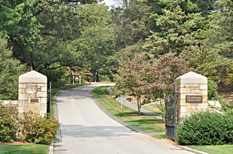
Wildwood Cemetery is a 70.5-acre burial ground on a rolling, suburban hillside beside Wedge Pond in Winchester, Massachusetts. It grew out of the town's incorporation in 1850, when a bequest from Colonel William Winchester funded land purchase after the old churchyard ran out of room. Amasa Farrier, the Stoneham town surveyor, designed the layout, drawing on the ideas of John Claudius Loudon and Andrew Jackson Downing. Winding footpaths and carriage roads follow the contours of the land, and the grounds have shade trees and lawns in the manner of Mount Auburn Cemetery in Cambridge. The cemetery was consecrated in September 1852, and bodies from the old church graveyard were moved there in 1853. Olmsted & Associates designed a landscaped entrance in 1937. About 5,000 stones record burials from 1805 to 1988, including early local families and prominent figures. It was recognized as a fine example of garden cemetery design and as the town's first planned public space.
Significance in brief: The nomination argues it is a notable example of a small mid-nineteenth century rural garden cemetery, modeled on Mount Auburn Cemetery. Its winding footpaths and carriage roads follow the rolling terrain and reflect picturesque landscape ideals. It was also the earliest planned public space in the newly incorporated town of Winchester.
Machine-generated summary. This summary was generated by a language model from the official nomination document and has not been reviewed line by line by an editor. It may contain errors. Check the source document before relying on any detail. Source: nomination document (PDF) · National Archives catalog entry. NRHP reference 89000658, listed July 5, 1989. Summary generated October 2026 (model claude-sonnet-5-5, prompt v1.0-2026-10-29, confidence medium).
Key facts
| Address | 34 Palmer St. (formerly Wildwood St.), Winchester |
|---|---|
| County | Middlesex County |
| Listed | July 5, 1989 |
| Reference number | 89000658 |
| Resource type | Site |
| Architect / builder | Amasa Farrier (designer, Stoneham town surveyor); entrance gateway by Olmsted & Associates of Boston, 1937 |
| Architectural style | Rural garden cemetery |
| Criteria |
|
| Areas of significance | Landscape Architecture |
| Level of significance | Local |
| Status (as stated in the nomination) | Condition described as excellent. |
| Acreage | 70.5 |
| Coordinates | 42.45519, -71.14616 (NPS GIS) |
What listing means for this property
Sites (archaeological sites, battlefields, landscapes) are often listed with a restricted address to protect them from looting or disturbance. Listing is honorary for private owners; federal undertakings on or near the site go through Section 106 review, and state laws may protect burials and artefacts regardless of listing.
General information, not legal or tax advice. Rules change; confirm with your State Historic Preservation Office or a qualified adviser.
Sources and further reading
- National Park Service, National Register of Historic Places database (snapshot May 2026), reference 89000658.
- Nomination form (PDF, National Archives) — catalog entry
- Wikipedia article (used for cross-checking only; text not reproduced here)
- Wikidata Q8001561
- This listing as JSON
Last updated October 2026. Found an error? See the editorial policy for how to report it.