Silver Hill Historic District

Why it's listed
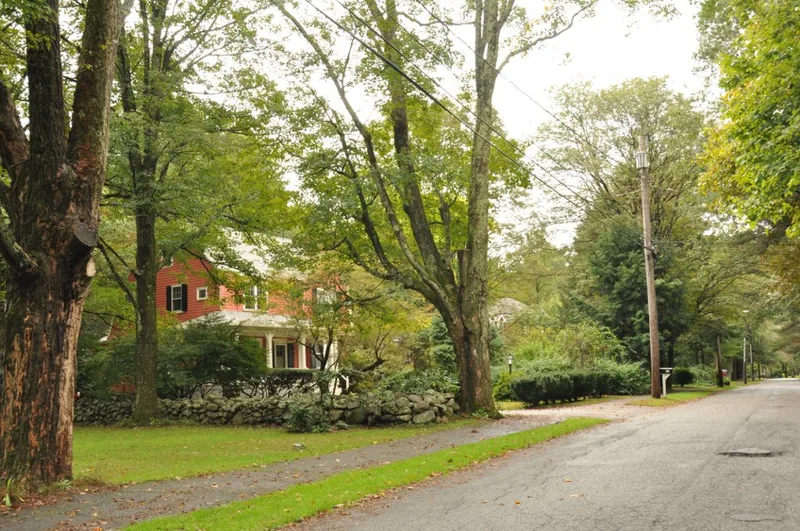
Silver Hill is a residential neighborhood of about 54 acres in the northwest corner of Weston, a Boston suburb. It includes part of Merriam Street, an old country road, along with Silver Hill Road and part of Westland Road. The district holds 80 resources, mainly wood-frame houses in Queen Anne and Colonial Revival styles, many on fieldstone foundations with generous porches. The earliest house dates to 1892, and most were built between 1905 and 1941. The area matters because the Weston Land Association, a joint stock company funded by middle-class investors, laid out Silver Hill and Westland Roads in 1905 as the town's first large-scale subdivision. Early owners included skilled tradesmen and white-collar workers. Waltham architect George Strout designed several of the early houses, including the Washburn house at 198 Merriam Street. The district was listed for its role in community planning and for its architecture, with a period of significance from 1892 to 1954.
Significance in brief: It is the site of Weston's first large-scale subdivision, laid out in 1905 by the Weston Land Association to supply middle-class housing. It also holds a cohesive group of Queen Anne and Colonial Revival houses that are uncommon in Weston. The district is listed under Criteria A and C at the local level.
Machine-generated summary. This summary was generated by a language model from the official nomination document and has not been reviewed line by line by an editor. It may contain errors. Check the source document before relying on any detail. Source: nomination document (PDF) · National Archives catalog entry. NRHP reference 04000902, listed August 25, 2004. Summary generated October 2026 (model claude-sonnet-5-5, prompt v1.0-2026-10-29, confidence high).
Key facts
| Address | Silver Hill, Westland Rds., Merriam St., Weston |
|---|---|
| County | Middlesex County |
| Listed | August 25, 2004 |
| Reference number | 04000902 |
| Resource type | District |
| Period of significance | 1892-1954 |
| Architect / builder | George Strout, J.R. Worcester (civil engineer) |
| Architectural style | Late Victorian: Italianate, Queen Anne; Late 19th & 20th Century Revivals: Colonial Revival |
| Criteria |
|
| Areas of significance | Architecture, Community Planning and Development |
| Level of significance | Local |
| Status (as stated in the nomination) | Residential neighborhood still in use as single dwellings with secondary structures; some houses have been renovated or expanded, and 14 buildings are non-contributing. |
| Acreage | 54 |
| Coordinates | 42.39261, -71.30501 (NPS GIS) |
What listing means for this property
This is a historic district. Buildings within its boundary are either contributing (they add to the district's significance) or non-contributing. Owners of contributing income-producing buildings can claim the 20% federal rehabilitation tax credit; homeowners should look at state credits. National Register districts impose no design review by themselves; a local historic district ordinance, if one exists, does (the difference explained).
General information, not legal or tax advice. Rules change; confirm with your State Historic Preservation Office or a qualified adviser.
Sources and further reading
- National Park Service, National Register of Historic Places database (snapshot May 2026), reference 04000902.
- Nomination form (PDF, National Archives) — catalog entry
- Wikipedia article (used for cross-checking only; text not reproduced here)
- Wikidata Q2286522
- This listing as JSON
Last updated October 2026. Found an error? See the editorial policy for how to report it.