Shawsheen Cemetery
Also known as: Shawshine Cemetery

Why it's listed
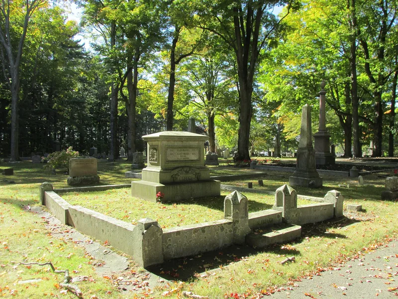
Shawsheen Cemetery is a town-owned burial ground in eastern Bedford, Massachusetts, opened in 1849 as a large, modern replacement for the Old Burying Ground of 1729. The listed portion covers about 17 acres of the 44-acre site: the original 10-acre section laid out in the rural cemetery style, plus four small later additions. Roads radiate from a central circle, family plots line the avenues, and mature maples and pines shape the setting. Markers range from slate tablets relocated from the old ground to marble, zinc and granite monuments, box tombs, a receiving tomb, the 1874 Soldiers' Memorial and the 1906-1907 Memorial Gates. Burials include shoe manufacturers, physicians such as William Richardson Hayden, entrepreneurs, civic officers and veterans from the Revolutionary War through the Civil War. Citizens' Lots hold unknown or poor individuals. The cemetery remains in use and is well kept, and it was listed for its local historical and design importance.
Significance in brief: The nomination argues it is significant under Criteria A and C at the local level, plus consideration D for cemeteries. It is Bedford's primary secular burial ground, with a rural-cemetery layout and a range of 19th and early 20th century monuments. It holds the graves of manufacturers, physicians, entrepreneurs, civic leaders and war veterans who shaped the town.
Machine-generated summary. This summary was generated by a language model from the official nomination document and has not been reviewed line by line by an editor. It may contain errors. Check the source document before relying on any detail. Source: nomination document (PDF) · National Archives catalog entry. NRHP reference 07000547, listed June 12, 2007. Summary generated October 2026 (model claude-sonnet-5-5, prompt v1.0-2026-10-29, confidence medium).
Key facts
| Address | Great Rd. and Shawsheen Rd., Bedford |
|---|---|
| County | Middlesex County |
| Listed | June 12, 2007 |
| Reference number | 07000547 |
| Resource type | Site |
| Architectural style | Rural cemetery style landscape (Architectural Classification listed as N/A) |
| Criteria |
|
| Areas of significance | Art, Community Planning and Development, Landscape Architecture, Social History |
| Level of significance | Local |
| Status (as stated in the nomination) | Still an active burial ground in both old and new sections, well maintained by the town's Department of Public Works; monuments are largely upright with little breakage. |
| Acreage | 16.9 |
| Coordinates | 42.48527, -71.25686 (NPS GIS) |
What listing means for this property
Sites (archaeological sites, battlefields, landscapes) are often listed with a restricted address to protect them from looting or disturbance. Listing is honorary for private owners; federal undertakings on or near the site go through Section 106 review, and state laws may protect burials and artefacts regardless of listing.
General information, not legal or tax advice. Rules change; confirm with your State Historic Preservation Office or a qualified adviser.
Sources and further reading
- National Park Service, National Register of Historic Places database (snapshot May 2026), reference 07000547.
- Nomination form (PDF, National Archives) — catalog entry
- Wikipedia article (used for cross-checking only; text not reproduced here)
- Wikidata Q7491589
- This listing as JSON
Last updated October 2026. Found an error? See the editorial policy for how to report it.