Fairview Cemetery
Also known as: East Burying Ground

Why it's listed
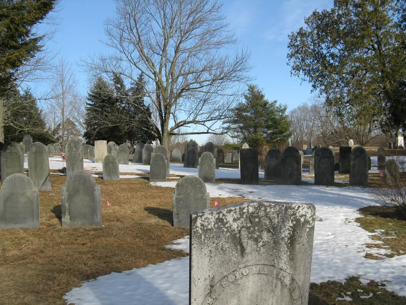
Fairview Cemetery sits on Main Street in Westford, about a mile east of the town center. Known first as the East Burying Ground, it came into use in the early 18th century, and an early stone is reputed to bear the date 1702. Roughly 300 Colonial slate markers survive in the central section, carved with death's heads, portals and, later, urns and willows. In the late 19th century the town's cemetery commissioners reshaped the grounds on the model of Rural cemeteries, building granite walls and gateways, grading avenues and planting trees. Engineer Edward Symmes drew the 1876 plan for the curving paths of the East Division, and the cemetery took the name Fairview in 1896 after a petition. Later additions came in 1924 and 1936. About 10,000 people are buried here, from mill owners and ministers to farmers and mill hands. The cemetery still receives burials, though no plots remain for sale. Its markers, tombs, walls and a summer house record changing tastes in memorial design.
Significance in brief: The cemetery is the town's oldest and largest burial ground, with about 10,000 burials and roughly 300 Colonial slate markers. It shows the shift from a plain colonial burial ground to a Garden-style cemetery, with walls, gateways and curving avenues laid out from an 1876 plan by engineer Edward Symmes. Its gravestones illustrate changing carving styles and attitudes toward death, and it contains the graves of local industrialists, politicians, ministers, mill hands and farmers.
Machine-generated summary. This summary was generated by a language model from the official nomination document and has not been reviewed line by line by an editor. It may contain errors. Check the source document before relying on any detail. Source: nomination document (PDF) · National Archives catalog entry. NRHP reference 04001472, listed January 12, 2005. Summary generated October 2026 (model claude-sonnet-5-5, prompt v1.0-2026-10-29, confidence medium).
Key facts
| Address | Main St., Westford |
|---|---|
| County | Middlesex County |
| Listed | January 12, 2005 |
| Reference number | 04001472 |
| Resource type | Site |
| Architect / builder | Edward Symmes (1876 plan); stone walls by Nathan S. Hamblin and George Yapp; hearse house by George Drew |
| Architectural style | N/A (Rural/Garden cemetery landscape) |
| Areas of significance | Art, Community Planning and Development, Social History |
| Level of significance | Local |
| Status (as stated in the nomination) | The cemetery remains in use for burials but has run out of plots to sell; the former hearse house serves as the superintendent's office. |
| Acreage | 10.5 |
| Coordinates | 42.58727, -71.42015 (NPS GIS) |
What listing means for this property
Sites (archaeological sites, battlefields, landscapes) are often listed with a restricted address to protect them from looting or disturbance. Listing is honorary for private owners; federal undertakings on or near the site go through Section 106 review, and state laws may protect burials and artefacts regardless of listing.
General information, not legal or tax advice. Rules change; confirm with your State Historic Preservation Office or a qualified adviser.
Sources and further reading
- National Park Service, National Register of Historic Places database (snapshot May 2026), reference 04001472.
- Nomination form (PDF, National Archives) — catalog entry
- Wikipedia article (used for cross-checking only; text not reproduced here)
- Wikidata Q5430803
- This listing as JSON
Last updated October 2026. Found an error? See the editorial policy for how to report it.