Echo Bridge

Why it's listed
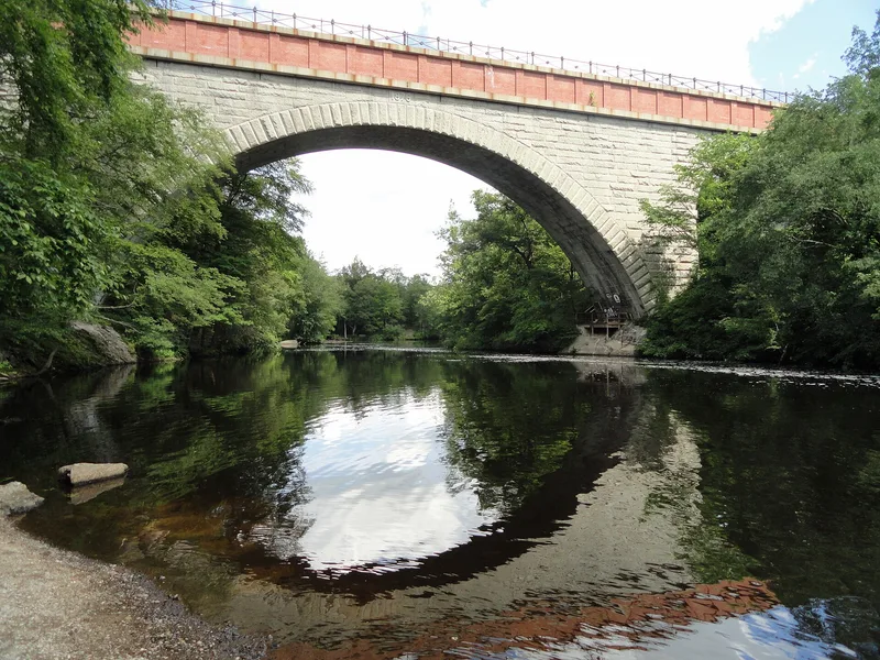
Echo Bridge carries a section of the Sudbury River aqueduct across the Charles River and Ellis Street, joining Needham to Newton Upper Falls in Massachusetts. Built in 1876-1877 of granite with brick and concrete above, it has seven arches. The largest, a segmental arch over the river, spans about 130 feet and was for many years the second longest masonry arch in the United States. The conduit was part of a system bringing water to Boston's growing population. The bridge's location was chosen to disturb the village at Newton Upper Falls as little as possible, and its base was widened to deal with unstable rock on the east bank. The main arch settled only two inches when its supporting framework was removed. The name comes from the echo heard beneath the arch. Set in Hemlock Gorge, an early Metropolitan District Commission recreation area, the bridge now also serves as a pedestrian walkway between two parks.
Significance in brief: The nomination cites its role in the development of Boston's nineteenth-century water supply system and its engineering. Its main arch of nearly 130 feet was for many years the second longest masonry arch in the United States. It lies in Hemlock Gorge, an early Metropolitan District Commission recreation area tied to the conservation movement.
Machine-generated summary. This summary was generated by a language model from the official nomination document and has not been reviewed line by line by an editor. It may contain errors. Check the source document before relying on any detail. Source: nomination document (PDF) · National Archives catalog entry. NRHP reference 80000638, listed April 9, 1980. Summary generated October 2026 (model claude-sonnet-5-5, prompt v1.0-2026-10-29, confidence high).
Key facts
| Address | Spans Charles River, Newton |
|---|---|
| County | Middlesex County |
| Listed | April 9, 1980 |
| Reference number | 80000638 |
| Resource type | Structure |
| Period of significance | 1876-1877 |
| Areas of significance | Community Planning and Development, Conservation, Engineering, Architecture |
| Level of significance | State |
| Status (as stated in the nomination) | Described as structurally sound and in good condition, unaltered and on its original site. It still carries the conduit and also serves as a pedestrian walkway between two park areas. Graffiti was noted as disfiguring it. |
| Acreage | 0.9 |
| Within district | Newton Upper Falls Historic District |
| Coordinates | 42.31473, -71.22707 (NPS GIS) |
What listing means for this property
For a publicly owned building or structure, listing mainly matters when federal funds, permits or licences are involved: projects then go through Section 106 review so effects on the property are considered. Listing also strengthens applications for preservation grants and, for leased income-producing uses, can enable the federal rehabilitation tax credit.
General information, not legal or tax advice. Rules change; confirm with your State Historic Preservation Office or a qualified adviser.
Sources and further reading
- National Park Service, National Register of Historic Places database (snapshot May 2026), reference 80000638.
- Nomination form (PDF, National Archives) — catalog entry
- Wikipedia article (used for cross-checking only; text not reproduced here)
- Wikidata Q5332684
- This listing as JSON
Last updated October 2026. Found an error? See the editorial policy for how to report it.