Ringville Cemetery

Approximate location: the National Park Service places this pin arbitrarily within the property, not at a surveyed point (stated accuracy ±12 m).
Why it's listed
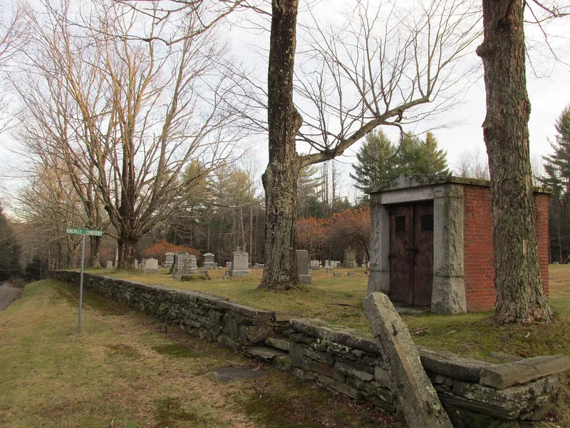
Ringville Cemetery sits on the south side of Witt Hill Road in the Worthington hamlet of Ringville, once a busy mill and dairy center. Roughly three acres in size, it is bounded on the road side by a fieldstone retaining wall with a granite cap, lined inside by tall sugar maples, and bordered by Watts Stream. Its earliest burials date to the 1840s, and the town assembled the grounds through land purchases between 1866 and 1887, adding another acre later. About 300 stones of granite, marble, schist and brownstone include Victorian markers, obelisks, and a set of graves reportedly moved from Ireland Street. The brick and granite Blair Vault, built about 1927, is the most prominent structure. The cemetery was listed for its reflection of Ringville's growth through the Ring family mills and other local enterprises, for burials of figures such as the parents of Temple University founder Russell Conwell, and for its landscape and locally carved gravestones. The town still buries there.
Significance in brief: The nomination argues the cemetery reflects the growth of the Ringville mill hamlet in the mid-1800s, and holds the graves of local mill-owning families, parents of Russell Conwell, and 35 veterans. It also cites its landscape features, including a fieldstone wall, mature sugar maples and the ca. 1927 Blair Vault, along with locally carved gravestones.
Machine-generated summary. This summary was generated by a language model from the official nomination document and has not been reviewed line by line by an editor. It may contain errors. Check the source document before relying on any detail. Source: nomination document (PDF) · National Archives catalog entry. NRHP reference 04000024, listed February 11, 2004. Summary generated October 2026 (model claude-sonnet-5-5, prompt v1.0-2026-10-29, confidence high).
Key facts
| Address | Witt Hill Rd., Worthington |
|---|---|
| County | Hampshire County |
| Listed | February 11, 2004 |
| Reference number | 04000024 |
| Resource type | Site |
| Period of significance | 1847-1953 |
| Criteria |
|
| Areas of significance | Art, Social History, Landscape Architecture, Community Planning and Development |
| Level of significance | Local |
| Status (as stated in the nomination) | Still in use by the Town of Worthington for burials; the original layout and historic walls are described as preserved, and an acre was added in the late 1900s. |
| Acreage | 2.4 |
| Coordinates | 42.37037, -72.91501 (NPS GIS) |
What listing means for this property
Sites (archaeological sites, battlefields, landscapes) are often listed with a restricted address to protect them from looting or disturbance. Listing is honorary for private owners; federal undertakings on or near the site go through Section 106 review, and state laws may protect burials and artefacts regardless of listing.
General information, not legal or tax advice. Rules change; confirm with your State Historic Preservation Office or a qualified adviser.
Sources and further reading
- National Park Service, National Register of Historic Places database (snapshot May 2026), reference 04000024.
- Nomination form (PDF, National Archives) — catalog entry
- Wikipedia article (used for cross-checking only; text not reproduced here)
- Wikidata Q7335004
- This listing as JSON
Last updated October 2026. Found an error? See the editorial policy for how to report it.