Center Cemetery

Why it's listed
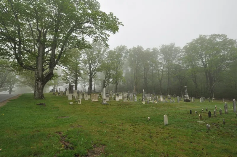
Center Cemetery is a 2.4-acre rural burial ground on Sam Hill Road, close to Worthington Center in Hampshire County, Massachusetts. Its earliest burial dates to about 1774, and burials continue today. Rows of mature sugar maples and fieldstone walls frame the grounds, and turf and dirt cart paths divide it into four sections that reflect changing burial practices from the 1770s onward. Of its 631 markers, about 63 percent are marble and 33 percent granite. Several older stones are carved in Goshen Stone, and a number carry the signed work of regional carvers. The 1777 stone of Jereme Kinne bears a rare Hampton Indian motif. The cemetery holds the graves of many original settlers, the town's first minister, officials, prominent families such as the Brewsters and Starkweathers, and 51 veterans. Its landscape and gravestone artistry, along with its connection to the town's founding, account for its listing.
Significance in brief: The cemetery is significant under Criterion A for its link to the town's founding families, early officials, church founders and veterans, and under Criterion C for its landscape features and locally carved gravestones. It includes signed work by regional stone carvers and a rare Hampton Indian motif stone from 1777. It retains the character of an 18th-century rural burial ground.
Machine-generated summary. This summary was generated by a language model from the official nomination document and has not been reviewed line by line by an editor. It may contain errors. Check the source document before relying on any detail. Source: nomination document (PDF) · National Archives catalog entry. NRHP reference 04000084, listed February 26, 2004. Summary generated October 2026 (model claude-sonnet-5-5, prompt v1.0-2026-10-29, confidence high).
Key facts
| Address | Sam Hill Rd., Worthington |
|---|---|
| County | Hampshire County |
| Listed | February 26, 2004 |
| Reference number | 04000084 |
| Resource type | Site |
| Period of significance | 1774-1954 |
| Architect / builder | G. Fleming; H. Pomeroy; Logan & Joyner; F. Munnier; T. Sturges; Rule & Marble (stone carvers) |
| Criteria |
|
| Areas of significance | Art, Social History, Landscape Architecture, Community Planning and Development |
| Level of significance | Local |
| Status (as stated in the nomination) | Still in use as a cemetery, with new burials continuing; owned by the Town of Worthington. |
| Acreage | 2.4 |
| Coordinates | 42.39447, -72.94288 (NPS GIS) |
What listing means for this property
Sites (archaeological sites, battlefields, landscapes) are often listed with a restricted address to protect them from looting or disturbance. Listing is honorary for private owners; federal undertakings on or near the site go through Section 106 review, and state laws may protect burials and artefacts regardless of listing.
General information, not legal or tax advice. Rules change; confirm with your State Historic Preservation Office or a qualified adviser.
Sources and further reading
- National Park Service, National Register of Historic Places database (snapshot May 2026), reference 04000084.
- Nomination form (PDF, National Archives) — catalog entry
- Wikipedia article (used for cross-checking only; text not reproduced here)
- Wikidata Q5059272
- This listing as JSON
Last updated October 2026. Found an error? See the editorial policy for how to report it.