McKnight District
Also known as: Highland District; See Also:McKnight District (Boundary Incre

Why it's listed
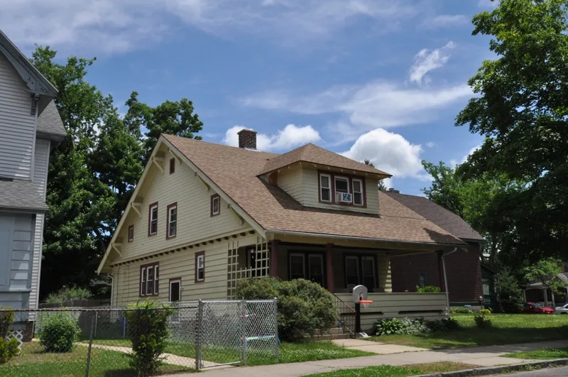
This 130-acre neighborhood in southwestern Springfield, Massachusetts, holds more than 350 houses laid out in the late nineteenth century by brothers John and William McKnight. Before 1870 the land held scattered farms, a ravine, a mineral spring and a black settlement near Lake Como. The McKnights bought the Flagg farm in 1870 and expanded in 1881. John planned streets, trees and shrubbery, while William directed construction of 25 to 40 houses a year. Five corner parks with fountains were set out, and part of the original grove was given to the city. Houses range through Italianate, Queen Anne, Shingle, Stick, Tudor and Colonial Revival designs, with Queen Anne dominating, and a consistent scale of two-and-a-half to three stories. The district is almost entirely residential, with two churches, a small store and a school built in 1887. It was Springfield's first large planned residential area and first suburb on the hill. Six mayors and basketball inventor James Naismith lived here. It became a local historic district in January 1976.
Significance in brief: The nomination argues the district is a large, well-preserved, planned late nineteenth-century residential development and the home of many prominent Springfield citizens. It was the first totally planned residential area of great size in Springfield and the city's first suburb atop the hill. The McKnights developed both houses and grounds, a practice other developers later followed.
Machine-generated summary. This summary was generated by a language model from the official nomination document and has not been reviewed line by line by an editor. It may contain errors. Check the source document before relying on any detail. Source: nomination document (PDF) · National Archives catalog entry. NRHP reference 76000255, listed April 26, 1976. Summary generated October 2026 (model claude-sonnet-5-5, prompt v1.0-2026-10-29, confidence medium).
Key facts
| Address | Roughly bounded by Penn Central, State St., the Armory, and includes both sides of Campus Pl., and Dartmouth St., Springfield |
|---|---|
| County | Hampden County |
| Listed | April 26, 1976 |
| Reference number | 76000255 |
| Resource type | District |
| Architect / builder | John D. McKnight and William McKnight (developers/builders); carpenter-builder Michael Maher; architects F. R. Richmond and B. H. Seabury (Tapley school), G. Wood Taylor, Guy Kirkham, George Pyne, F. S. Newman |
| Architectural style | Predominantly Queen Anne, with Italianate-Bracketed, mansard, Shingle, Stick, Tudor and Colonial Revival houses |
| Areas of significance | Community Planning and Development, Architecture |
| Level of significance | Local |
| Status (as stated in the nomination) | Described as in good condition, almost completely residential and virtually unaltered, with few intrusions; made a local historic district in January 1976. |
| Acreage | 130 |
| Coordinates | 42.11535, -72.57309 (NPS GIS) |
What listing means for this property
This is a historic district. Buildings within its boundary are either contributing (they add to the district's significance) or non-contributing. Owners of contributing income-producing buildings can claim the 20% federal rehabilitation tax credit; homeowners should look at state credits. National Register districts impose no design review by themselves; a local historic district ordinance, if one exists, does (the difference explained).
General information, not legal or tax advice. Rules change; confirm with your State Historic Preservation Office or a qualified adviser.
Sources and further reading
- National Park Service, National Register of Historic Places database (snapshot May 2026), reference 76000255.
- Nomination form (PDF, National Archives) — catalog entry
- Wikipedia article (used for cross-checking only; text not reproduced here)
- Wikidata Q6802025
- This listing as JSON
Last updated October 2026. Found an error? See the editorial policy for how to report it.