Mount Pleasant Cemetery

Why it's listed
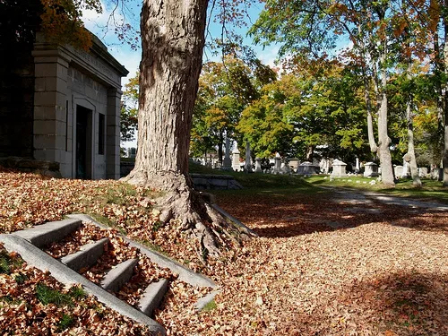
Mount Pleasant Cemetery occupies about ten acres roughly a mile from the center of Taunton, Massachusetts. It was laid out in 1836 by local surveyor Joseph Wilbar on land donated by Samuel Crocker, formerly the John King homestead. The King Family Burying Ground, whose oldest burial dates to 1710, became the nucleus of the new design. Curving gravel drives follow the rolling hills, which carry names such as Mount Crocker and Ridge Hill, and mature beech, maple and basswood trees line the grounds. The present appearance dates largely to the 1920s, when the George E. Wilbur Mausoleum and the King Memorial Gate were added. Monuments range from simple stones to refined classical designs, some attributed to carvers such as Alpheus Cary. The cemetery was recognized for its early rural cemetery design, its link to Taunton's settlement and growth, and as the burial place of industrialists, military officers and public officials. The city took over ownership in 1986.
Significance in brief: The nomination argues it is an early, well-preserved rural cemetery with a naturalistic layout that respectfully incorporated the pre-existing King family burial ground. It is tied to Taunton's settlement and community development, and it holds graves of many prominent business, government and military figures. It also contains a notable collection of monuments, mausoleum and gates.
Machine-generated summary. This summary was generated by a language model from the official nomination document and has not been reviewed line by line by an editor. It may contain errors. Check the source document before relying on any detail. Source: nomination document (PDF) · National Archives catalog entry. NRHP reference 02001474, listed December 5, 2002. Summary generated October 2026 (model claude-sonnet-5-5, prompt v1.0-2026-10-29, confidence medium).
Key facts
| Address | Crocker, Cohannet, and Barnum Sts., Taunton |
|---|---|
| County | Bristol County |
| Listed | December 5, 2002 |
| Reference number | 02001474 |
| Resource type | Site |
| Period of significance | 1710-1952 |
| Architect / builder | Joseph Wilbar, designer |
| Criteria |
|
| Areas of significance | Landscape Architecture, Community Planning and Development, Social History |
| Level of significance | Local |
| Status (as stated in the nomination) | Still an active cemetery; the last lot was sold in 1984 but burials continue in family plots. Owned by the City of Taunton since 1986. The maple trees are described as in very poor condition. |
| Acreage | 10 |
| Coordinates | 41.89518, -71.09909 (NPS GIS) |
What listing means for this property
Sites (archaeological sites, battlefields, landscapes) are often listed with a restricted address to protect them from looting or disturbance. Listing is honorary for private owners; federal undertakings on or near the site go through Section 106 review, and state laws may protect burials and artefacts regardless of listing.
General information, not legal or tax advice. Rules change; confirm with your State Historic Preservation Office or a qualified adviser.
Sources and further reading
- National Park Service, National Register of Historic Places database (snapshot May 2026), reference 02001474.
- Nomination form (PDF, National Archives) — catalog entry
- Wikipedia article (used for cross-checking only; text not reproduced here)
- Wikidata Q14715728
- This listing as JSON
Last updated October 2026. Found an error? See the editorial policy for how to report it.